Saint-Cirgues-de-Prades
Saint-Cirgues-de-Prades ist eine französische Gemeinde mit 139 Einwohnern (Stand 1. Januar 2019) im Département Ardèche in der Region Auvergne-Rhône-Alpes. Sie gehört zum Kanton Haute-Ardèche im Arrondissement Largentière.
| Saint-Cirgues-de-Prades | ||
|---|---|---|
| ||
| Staat | Frankreich | |
| Region | Auvergne-Rhône-Alpes | |
| Département (Nr.) | Ardèche (07) | |
| Arrondissement | Largentière | |
| Kanton | Haute-Ardèche | |
| Gemeindeverband | Ardèche des Sources et Volcans | |
| Koordinaten | 44° 37′ N, 4° 16′ O | |
| Höhe | 319–861 m | |
| Fläche | 3,47 km² | |
| Einwohner | 139 (1. Januar 2019) | |
| Bevölkerungsdichte | 40 Einw./km² | |
| Postleitzahl | 07380 | |
| INSEE-Code | 07223 | |

Geografie
Saint-Cirgues-de-Prades liegt am Fluss Salindre, einem rechten Nebenfluss des Galeizon und ist Teil des Regionalen Naturparks Monts d’Ardèche.
Bevölkerung
| Jahr | 1962 | 1968 | 1975 | 1982 | 1990 | 1999 | 2008 | |
|---|---|---|---|---|---|---|---|---|
| Einwohner | 98 | 83 | 69 | 62 | 85 | 98 | 128 | |
| Quellen: Cassini und INSEE | ||||||||
Sehenswürdigkeiten
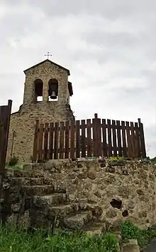
Kirche Saint-Cirgues
- Kirche Saint-Cirgues
This article is issued from Wikipedia. The text is licensed under Creative Commons - Attribution - Sharealike. The authors of the article are listed here. Additional terms may apply for the media files, click on images to show image meta data.