Saint-Étienne-de-Fontbellon
Saint-Étienne-de-Fontbellon ist eine französische Gemeinde im Département Ardèche in der Region Auvergne-Rhône-Alpes mit 2833 Einwohnern (Stand 1. Januar 2019).
| Saint-Étienne-de-Fontbellon | ||
|---|---|---|
| ||
| Staat | Frankreich | |
| Region | Auvergne-Rhône-Alpes | |
| Département (Nr.) | Ardèche (07) | |
| Arrondissement | Largentière | |
| Kanton | Aubenas-2 | |
| Gemeindeverband | Bassin d’Aubenas | |
| Koordinaten | 44° 36′ N, 4° 23′ O | |
| Höhe | 167–406 m | |
| Fläche | 9,63 km² | |
| Einwohner | 2.833 (1. Januar 2019) | |
| Bevölkerungsdichte | 294 Einw./km² | |
| Postleitzahl | 07200 | |
| INSEE-Code | 07231 | |
| Website | www.mairie-st-etienne-de-fontbellon.fr | |
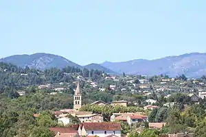 Dorfansicht | ||

Geographie
Das Dorf liegt im Tal des Flusses Ardèche, südlich von Aubenas. Nördlich des Ortes liegt der Regionale Naturpark Monts d’Ardèche, im sogenannten Piémont Cévenol.
Weblinks
Commons: Saint-Étienne-de-Fontbellon – Sammlung von Bildern, Videos und Audiodateien
- Offizielle Website der Gemeinde Saint-Étienne-de-Fontbellon (französisch)
- fontbellon.free.fr – Private Website über die Gemeinde (französisch)
This article is issued from Wikipedia. The text is licensed under Creative Commons - Attribution - Sharealike. The authors of the article are listed here. Additional terms may apply for the media files, click on images to show image meta data.