Tupigny
Tupigny ist eine französische Gemeinde mit 328 Einwohnern (Stand 1. Januar 2019) im Département Aisne in der Region Hauts-de-France (vor 2016 Picardie). Sie gehört zum Arrondissement Vervins, zum Kanton Guise und zum Kommunalverband Thiérache Sambre et Oise.
| Tupigny | ||
|---|---|---|
| ||
| Staat | Frankreich | |
| Region | Hauts-de-France | |
| Département (Nr.) | Aisne (02) | |
| Arrondissement | Vervins | |
| Kanton | Guise | |
| Gemeindeverband | Thiérache Sambre et Oise | |
| Koordinaten | 49° 57′ N, 3° 36′ O | |
| Höhe | 95–178 m | |
| Fläche | 13,03 km² | |
| Einwohner | 328 (1. Januar 2019) | |
| Bevölkerungsdichte | 25 Einw./km² | |
| Postleitzahl | 02120 | |
| INSEE-Code | 02753 | |
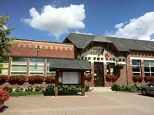 Rathaus (Mairie) von Tupigny | ||

Geografie

Sambre-Oise-Kanal
Die Gemeinde Tupigny liegt am Sambre-Oise-Kanal, 24 Kilometer nordöstlich von Saint-Quentin. Umgeben wird Tupigny von den Nachbargemeinden Wassigny im Norden, Vénérolles im Nordosten, Hannapes im Osten, Lesquielles-Saint-Germain im Südosten, Grand-Verly im Süden, Petit-Verly im Südwesten und Mennevret im Nordwesten.
Bevölkerungsentwicklung
| Jahr | 1962 | 1968 | 1975 | 1982 | 1990 | 1999 | 2007 | 2019 |
| Einwohner | 450 | 436 | 381 | 330 | 348 | 350 | 360 | 328 |
| Quellen: Cassini und INSEE | ||||||||
Sehenswürdigkeiten
- Kirche Sainte-Madeleine

Kirche Sainte-Madeleine
Weblinks
Commons: Tupigny – Sammlung von Bildern, Videos und Audiodateien
This article is issued from Wikipedia. The text is licensed under Creative Commons - Attribution - Sharealike. The authors of the article are listed here. Additional terms may apply for the media files, click on images to show image meta data.