Lavaqueresse
Lavaqueresse ist eine französische Gemeinde mit 201 Einwohnern (Stand: 1. Januar 2019) im Département Aisne in der Region Hauts-de-France. Sie gehört zum Arrondissement Vervins, zum Kanton Guise und zum Kommunalverband Thiérache Sambre et Oise.
| Lavaqueresse | ||
|---|---|---|
| ||
| Staat | Frankreich | |
| Region | Hauts-de-France | |
| Département (Nr.) | Aisne (02) | |
| Arrondissement | Vervins | |
| Kanton | Guise | |
| Gemeindeverband | Thiérache Sambre et Oise | |
| Koordinaten | 49° 57′ N, 3° 43′ O | |
| Höhe | 132–175 m | |
| Fläche | 4,53 km² | |
| Einwohner | 201 (1. Januar 2019) | |
| Bevölkerungsdichte | 44 Einw./km² | |
| Postleitzahl | 02450 | |
| INSEE-Code | 02414 | |

Geografie
Lavaqueresse liegt am Fluss Iton. Umgeben wird Lavaqueresse von den Nachbargemeinden Dorengt im Norden, Leschelle im Nordosten, Chigny im Südosten, Malzy im Süden, Villers-lès-Guise im Südwesten sowie Iron im Westen.
Bevölkerungsentwicklung
| Jahr | 1962 | 1968 | 1975 | 1982 | 1990 | 1999 | 2009 | 2015 |
| Einwohner | 320 | 310 | 259 | 256 | 224 | 209 | 212 | 207 |
| Quelle: Cassini und INSEE | ||||||||
Sehenswürdigkeiten
- Wehrkirche Notre-Dame-de-l'Assomption, Monument historique seit 1927
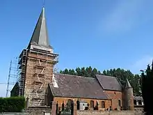
Kirche Notre-Dame-de-l'Assomption
Weblinks
Commons: Lavaqueresse – Sammlung von Bildern, Videos und Audiodateien
This article is issued from Wikipedia. The text is licensed under Creative Commons - Attribution - Sharealike. The authors of the article are listed here. Additional terms may apply for the media files, click on images to show image meta data.