Saint-Hilaire-sur-Erre
Saint-Hilaire-sur-Erre ist eine französische Gemeinde mit 531 Einwohnern (Stand: 1. Januar 2019) im Département Orne in der Region Normandie. Sie gehört zum Arrondissement Mortagne-au-Perche und zum Kanton Ceton.
| Saint-Hilaire-sur-Erre | ||
|---|---|---|
| ||
| Staat | Frankreich | |
| Region | Normandie | |
| Département (Nr.) | Orne (61) | |
| Arrondissement | Mortagne-au-Perche | |
| Kanton | Ceton | |
| Gemeindeverband | Communauté de communes des Collines du Perche Normand | |
| Koordinaten | 48° 19′ N, 0° 44′ O | |
| Höhe | 96–188 m | |
| Fläche | 15,36 km² | |
| Einwohner | 531 (1. Januar 2019) | |
| Bevölkerungsdichte | 35 Einw./km² | |
| Postleitzahl | 61340 | |
| INSEE-Code | 61405 | |

Geografie
Der Namenszusatz ist vom Flüsschen Erre, einem Zufluss der Huisne, abgeleitet. Nachbargemeinden sind Perche en Nocé im Nordwesten, Berd'huis im Nordosten, Nogent-le-Rotrou im Osten und Val-au-Perche im Süden und Westen.
Bevölkerungsentwicklung
| Jahr | 1962 | 1968 | 1975 | 1982 | 1990 | 1999 | 2008 | 2015 |
|---|---|---|---|---|---|---|---|---|
| Einwohner | 416 | 377 | 399 | 421 | 460 | 520 | 596 | 533 |
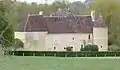 Schloss von Saint-Hilaire-sur-Erre
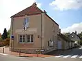 Mairie Saint-Hilaire-sur-Erre
This article is issued from Wikipedia. The text is licensed under Creative Commons - Attribution - Sharealike. The authors of the article are listed here. Additional terms may apply for the media files, click on images to show image meta data.