Aubry-le-Panthou
| Aubry-le-Panthou | ||
|---|---|---|

|
| |
| Staat | Frankreich | |
| Region | Normandie | |
| Département (Nr.) | Orne (61) | |
| Arrondissement | Mortagne-au-Perche | |
| Kanton | Vimoutiers | |
| Gemeindeverband | Vallées d’Auge et du Merlerault | |
| Koordinaten | 48° 51′ N, 0° 14′ O | |
| Höhe | 133–256 m | |
| Fläche | 6,86 km² | |
| Einwohner | 120 (1. Januar 2019) | |
| Bevölkerungsdichte | 17 Einw./km² | |
| Postleitzahl | 61120 | |
| INSEE-Code | 61010 | |

Aubry-le-Panthou ist eine französische Gemeinde mit 120 Einwohnern (Stand 1. Januar 2019) im Département Orne in der Region Normandie. Sie gehört zum Arrondissement Mortagne-au-Perche und zum Kanton Vimoutiers.
Geographie
Die Gemeinde liegt rund 20 Kilometer nordöstlich von Argentan. Sie wird vom Fluss Vie durchquert. Nachbargemeinden sind: Roiville im Norden, Neuville-sur-Touques im Nordosten, Mardilly im Südosten, La Fresnaie-Fayel im Süden, Survie im Südwesten und Fresnay-le-Samson im Nordwesten.
Bevölkerungsentwicklung
| Jahr | 1962 | 1968 | 1975 | 1982 | 1990 | 1999 | 2007 | 2012 | 2018 |
| Einwohner | 203 | 207 | 121 | 89 | 106 | 93 | 98 | 107 | 116 |
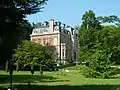 Château d'Osmont
 Buddhistischer Tempel Vajradhara-Ling
 Kirche Saint-Germain
This article is issued from Wikipedia. The text is licensed under Creative Commons - Attribution - Sharealike. The authors of the article are listed here. Additional terms may apply for the media files, click on images to show image meta data.