Saint-Floret
Saint-Floret ist eine französische Gemeinde mit 245 Einwohnern (Stand 1. Januar 2019) im Département Puy-de-Dôme in der Region Auvergne-Rhône-Alpes. Sie gehört zum Arrondissement Issoire und zum Kanton Le Sancy.
| Saint-Floret | ||
|---|---|---|
.svg.png.webp)
|
| |
| Staat | Frankreich | |
| Region | Auvergne-Rhône-Alpes | |
| Département (Nr.) | Puy-de-Dôme (63) | |
| Arrondissement | Issoire | |
| Kanton | Le Sancy | |
| Gemeindeverband | Agglo Pays d’Issoire | |
| Koordinaten | 45° 33′ N, 3° 6′ O | |
| Höhe | 476–929 m | |
| Fläche | 12,27 km² | |
| Einwohner | 245 (1. Januar 2019) | |
| Bevölkerungsdichte | 20 Einw./km² | |
| Postleitzahl | 63320 | |
| INSEE-Code | 63342 | |

Bevölkerungsentwicklung
| Jahr | 1962 | 1968 | 1975 | 1982 | 1990 | 1999 | 2007 | |
| Einwohner | 243 | 276 | 251 | 219 | 259 | 248 | 266 | |
| Quellen: Cassini und INSEE | ||||||||
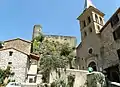
Sehenswürdigkeiten
- Mittelalterliche Brücke, die die Couze Pavin überspannt.
- Ruine der Festung (13. Jahrhundert) mit dem Donjon und einem Gebäude mit Tristan-und-Isolde-Fresken (14. Jahrhundert)
- Romanische Kapelle (12. Jahrhundert) mit dem umgebenden Friedhof
 Kirche Saint-Flour
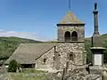 Obere Kirche (Église Haute oder Église du Chastel)
Literatur
- Charles-Laurent Salch: Dictionnaire des châteaux et des fortifications du Moyen Age en France. Éditions Publitotal, Strasbourg 1979, S. 1028 (Reprint. ebenda 1987, ISBN 2-86535-070-3).
Weblinks
Commons: Saint-Floret – Sammlung von Bildern, Videos und Audiodateien
This article is issued from Wikipedia. The text is licensed under Creative Commons - Attribution - Sharealike. The authors of the article are listed here. Additional terms may apply for the media files, click on images to show image meta data.