La Godivelle
La Godivelle ist eine französische Gemeinde mit 16 Einwohnern (Stand 1. Januar 2019) im Département Puy-de-Dôme in der Region Auvergne-Rhône-Alpes (vor 2016 Auvergne). Sie gehört zum Arrondissement Issoire und zum Kanton Brassac-les-Mines (bis 2015 Ardes).
| La Godivelle | ||
|---|---|---|
.svg.png.webp)
|
| |
| Staat | Frankreich | |
| Region | Auvergne-Rhône-Alpes | |
| Département (Nr.) | Puy-de-Dôme (63) | |
| Arrondissement | Issoire | |
| Kanton | Brassac-les-Mines | |
| Gemeindeverband | Agglo Pays d’Issoire | |
| Koordinaten | 45° 23′ N, 2° 55′ O | |
| Höhe | 1076–1377 m | |
| Fläche | 15,45 km² | |
| Einwohner | 16 (1. Januar 2019) | |
| Bevölkerungsdichte | 1 Einw./km² | |
| Postleitzahl | 63850 | |
| INSEE-Code | 63169 | |
| Website | http://www.lagodivelle.fr/ | |
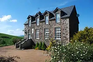 Rathaus (Mairie) von La Godivelle | ||

Geografie
La Godivelle liegt etwa 38 Kilometer südwestlich von Issoire am Ostabhang des Zentralmassivs. La Godivelle wird umgeben von den Nachbargemeinden Compains im Norden, Saint-Alyre-ès-Montagne im Osten, Montgreleix im Süden sowie Espinchal im Westen.
Bevölkerungsentwicklung
| Jahr | 1962 | 1968 | 1975 | 1982 | 1990 | 1999 | 2006 | 2013 |
| Einwohner | 110 | 106 | 70 | 62 | 38 | 27 | 22 | 17 |
| Quellen: Cassini und INSEE | ||||||||
Sehenswürdigkeiten
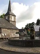
- Kirche Saint-Blaise aus dem 12. Jahrhundert
- Seen
This article is issued from Wikipedia. The text is licensed under Creative Commons - Attribution - Sharealike. The authors of the article are listed here. Additional terms may apply for the media files, click on images to show image meta data.