Rochefort-Montagne
| Rochefort-Montagne | ||
|---|---|---|
.svg.png.webp)
|
| |
| Staat | Frankreich | |
| Region | Auvergne-Rhône-Alpes | |
| Département (Nr.) | Puy-de-Dôme (63) | |
| Arrondissement | Issoire | |
| Kanton | Orcines | |
| Gemeindeverband | Dômes Sancy Artense | |
| Koordinaten | 45° 41′ N, 2° 48′ O | |
| Höhe | 771–1280 m | |
| Fläche | 17,55 km² | |
| Einwohner | 860 (1. Januar 2019) | |
| Bevölkerungsdichte | 49 Einw./km² | |
| Postleitzahl | 63210 | |
| INSEE-Code | 63305 | |
| Website | http://www.rochefort-montagne.com/ | |
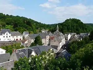 Blick auf Rochefort-Montagne | ||

Rochefort-Montagne ist eine französische Gemeinde mit 860 Einwohnern (Stand: 1. Januar 2019) im Département Puy-de-Dôme in der Region Auvergne-Rhône-Alpes. Olloix gehört zum Arrondissement Issoire und zum Kanton Orcines (bis 2015: Kanton Rochefort-Montagne).
Geographie
Rochefort-Montagne liegt etwa 23 Kilometer westsüdwestlich von Clermont-Ferrand. Umgeben wird Rochefort-Montagne von den Nachbargemeinden Saint-Pierre-Roche im Norden, Saint-Bonnet-près-Orcival im Nordosten, Orcival im Osten sowie Perpezat im Süden und Westen.
Bevölkerung
| Jahr | 1962 | 1968 | 1975 | 1982 | 1990 | 1999 | 2006 | 2013 |
| Einwohner | 1085 | 1077 | 1081 | 984 | 948 | 910 | 906 | 927 |
| Quellen: Cassini und INSEE | ||||||||
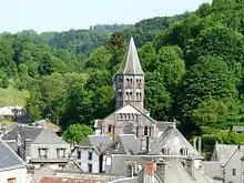
Sehenswürdigkeiten
- Kirche
This article is issued from Wikipedia. The text is licensed under Creative Commons - Attribution - Sharealike. The authors of the article are listed here. Additional terms may apply for the media files, click on images to show image meta data.