Ponérihouen
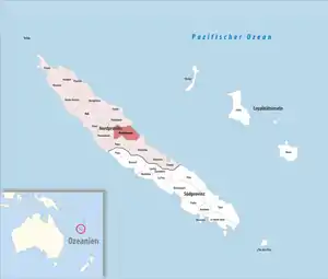
Ponérihouen ist eine Gemeinde in der Nordprovinz in Neukaledonien. Sie liegt auf der Hauptinsel Grande Terre.
| Ponérihouen | |
|---|---|
 | |
| Staat | Frankreich |
| Provinz | Nordprovinz |
| Aire coutumière | Paici-Camuki |
| Koordinaten | 21° 5′ S, 165° 24′ O |
| Höhe | 0–1330 m |
| Fläche | 617,25 km² |
| Einwohner | 2.420 (1. Januar 2019) |
| Bevölkerungsdichte | 4 Einw./km² |
| Postleitzahl | 98823 |
| INSEE-Code | 98823 |
Die höchste Erhebung ist der Aoupinié mit 1006 m.
Der Ort Ponérihouen liegt am Fluss Tchamba.
Bevölkerung
| Bevölkerungsentwicklung in Ponérihouen[1] | |||||||||||
|---|---|---|---|---|---|---|---|---|---|---|---|
| Einwohner | 1840 | 1853 | 1948 | 2065 | 1932 | 2326 | 2691 | 2726 | 2384 | 2370 | 2420 |
| Jahr | 1956 | 1963 | 1969 | 1976 | 1983 | 1989 | 1996 | 2004 | 2009 | 2014 | 2019 |
Einzelnachweise
- Bevölkerungsentwicklung in Ponérihouen 1956–2009 (Seite nicht mehr abrufbar, Suche in Webarchiven) Info: Der Link wurde automatisch als defekt markiert. Bitte prüfe den Link gemäß Anleitung und entferne dann diesen Hinweis.
This article is issued from Wikipedia. The text is licensed under Creative Commons - Attribution - Sharealike. The authors of the article are listed here. Additional terms may apply for the media files, click on images to show image meta data.