Ploulec’h
Ploulec’h (bretonisch: Ploulec’h) ist eine französische Gemeinde mit 1.579 Einwohnern (Stand: 1. Januar 2019) im Département Côtes-d’Armor in der Region Bretagne. Die Gemeinde gehört zum Arrondissement Lannion und zum Kanton Lannion. Die Einwohner werden Ploulec'hois genannt.
| Ploulec’h | ||
|---|---|---|
| ||
| Staat | Frankreich | |
| Region | Bretagne | |
| Département (Nr.) | Côtes-d’Armor (22) | |
| Arrondissement | Lannion | |
| Kanton | Lannion | |
| Gemeindeverband | Lannion-Trégor Communauté | |
| Koordinaten | 48° 43′ N, 3° 30′ W | |
| Höhe | 0–112 m | |
| Fläche | 10,18 km² | |
| Einwohner | 1.579 (1. Januar 2019) | |
| Bevölkerungsdichte | 155 Einw./km² | |
| Postleitzahl | 22300 | |
| INSEE-Code | 22224 | |
| Website | http://mairie.pagespro-orange.fr/communeploulech | |
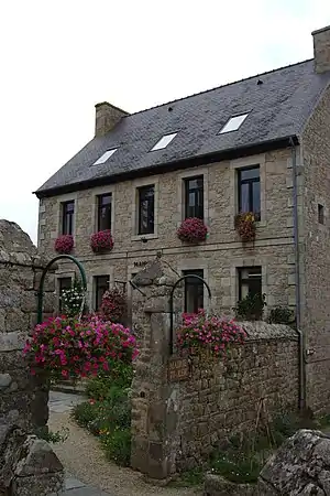 Rathaus von Ploulec’h | ||

Geographie
Ploulec’h liegt etwa 58 Kilometer westnordwestlich von Saint-Brieuc am Ästuar des Léguer. Umgeben wird Ploulec’h von den Nachbargemeinden Lannion im Norden und Osten, Ploubezre im Osten und Südosten sowie Ploumilliau im Süden und Westen.
Bevölkerungsentwicklung
| Jahr | 1962 | 1968 | 1975 | 1982 | 1990 | 1999 | 2006 | 2013 |
| Einwohner | 677 | 673 | 853 | 1.229 | 1.404 | 1.466 | 1.620 | 1.671 |
| Quelle: Cassini und INSEE | ||||||||
Sehenswürdigkeiten
Siehe auch: Liste der Monuments historiques in Ploulec’h
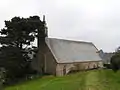
- Kirche Saint-Dogmaël
- Kapelle Notre-Dame in Yaudet
- gallorömisches Oppidum Yaudet
- Schloss Kerninon, Ende des 18. Jahrhunderts erbaut
 Kapelle Notre-Dame
_%C3%89glise_01.JPG.webp) Kirche Saint-Dogmaël
Kirche Saint-Dogmaël
Gemeindepartnerschaften
Mit der britischen Gemeinde St Erth in der Grafschaft Cornwall (England) besteht eine Partnerschaft.
Literatur
- Le Patrimoine des Communes des Côtes-d’Armor. Flohic Editions, Band 1, Paris 1998, ISBN 2-84234-017-5, S. 548–550.
This article is issued from Wikipedia. The text is licensed under Creative Commons - Attribution - Sharealike. The authors of the article are listed here. Additional terms may apply for the media files, click on images to show image meta data.