Plaisance (Aveyron)
Plaisance (okzitanisch Plasença) ist ein Ort und eine südfranzösische Gemeinde mit 218 Einwohnern (Stand 1. Januar 2019) im Département Aveyron in der Region Okzitanien (vor 2016 Midi-Pyrénées). Coupiac gehört zum Arrondissement Millau und zum Kanton Causses-Rougiers (bis 2015 Saint-Sernin-sur-Rance). Die Einwohner werden Plaisançais genannt.
| Plaisance Plasença | ||
|---|---|---|
| ||
| Staat | Frankreich | |
| Region | Okzitanien | |
| Département (Nr.) | Aveyron (12) | |
| Arrondissement | Millau | |
| Kanton | Causses-Rougiers | |
| Gemeindeverband | Saint Affricain, Roquefort, Sept Vallons | |
| Koordinaten | 43° 56′ N, 2° 33′ O | |
| Höhe | 229–647 m | |
| Fläche | 14,00 km² | |
| Einwohner | 218 (1. Januar 2019) | |
| Bevölkerungsdichte | 16 Einw./km² | |
| Postleitzahl | 12550 | |
| INSEE-Code | 12183 | |
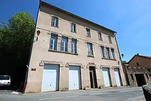 Rathaus (Mairie) von Plaisance | ||

Lage
Plaisance liegt etwa 38 Kilometer östlich von Albi im Südwesten der historischen Provinz Rouergue. Umgeben wird Plaisance von den Nachbargemeinden Coupiac im Norden und Osten, Balaguier-sur-Rance im Süden, Curvalle im Westen sowie La Bastide-Solages im Nordwesten.
Geschichte
Von 1833 bis 1874 gehörte Plaisance zu La Bastide-Solages.
Bevölkerungsentwicklung
| Jahr | 1962 | 1968 | 1975 | 1982 | 1990 | 1999 | 2006 | 2013 |
| Einwohner | 403 | 318 | 280 | 282 | 228 | 228 | 230 | 201 |
| Quelle: Cassini und INSEE | ||||||||
Sehenswürdigkeiten
- Kirche Saint-Martin, seit 1929 Monument historique
- Wegekreuz Saint-Eutrope, seit 1929 Monument historique
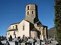 Kirche Saint-Martin
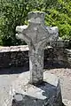 Wegekreuz Saint-Eutrope
Weblinks
Commons: Plaisance – Sammlung von Bildern, Videos und Audiodateien
This article is issued from Wikipedia. The text is licensed under Creative Commons - Attribution - Sharealike. The authors of the article are listed here. Additional terms may apply for the media files, click on images to show image meta data.