Mounes-Prohencoux
Mounes-Prohencoux ist ein Ort und eine südfranzösische Gemeinde mit 185 Einwohnern (Stand: 1. Januar 2019) im Département Aveyron in der Region Okzitanien (zuvor Midi-Pyrénées). Mounes-Prohencoux gehört zum Arrondissement Millau und zum Kanton Causses-Rougiers (bis 2015: Kanton Belmont-sur-Rance). Die Einwohner werden Mounésiens bzw. Mounésols genannt.
| Mounes-Prohencoux | ||
|---|---|---|
| ||
| Staat | Frankreich | |
| Region | Okzitanien | |
| Département (Nr.) | Aveyron (12) | |
| Arrondissement | Millau | |
| Kanton | Causses-Rougiers | |
| Gemeindeverband | Monts, Rance et Rougier | |
| Koordinaten | 43° 47′ N, 2° 51′ O | |
| Höhe | 440–951 m | |
| Fläche | 37,89 km² | |
| Einwohner | 185 (1. Januar 2019) | |
| Bevölkerungsdichte | 5 Einw./km² | |
| Postleitzahl | 12370 | |
| INSEE-Code | 12192 | |
 Blick auf Mounes | ||

Lage
Mounes-Prohencoux liegt etwa 46 Kilometer ostsüdöstlich von Albi im Südwesten der historischen Provinz Rouergue am Fluss Rance. Umgeben wird Mounes-Prohencoux von den Nachbargemeinden Montlaur im Norden, Camarès im Osten und Nordosten, Peux-et-Couffouleux im Südosten, Murasson im Süden und Südwesten sowie Belmont-sur-Rance im Westen und Nordwesten.
Bevölkerungsentwicklung
| Jahr | 1962 | 1968 | 1975 | 1982 | 1990 | 1999 | 2006 | 2013 |
| Einwohner | 420 | 344 | 266 | 243 | 233 | 190 | 197 | 183 |
| Quelle: Cassini und INSEE | ||||||||
Sehenswürdigkeiten
- Statuenmenhire
- Kirche Saint-Pierre in Mounes, 1848 bis 1852 erbaut
- Kirche Saint-Martin in Turipi
- Burg Falgous, Monument historique seit 1994
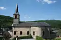 Kirche Saint-Pierre
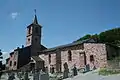 Kirche Saint-Martin
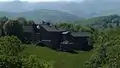 Burg Falgous
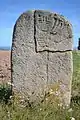 Statuenmenhir
Weblinks
Commons: Mounes-Prohencoux – Sammlung von Bildern, Videos und Audiodateien
This article is issued from Wikipedia. The text is licensed under Creative Commons - Attribution - Sharealike. The authors of the article are listed here. Additional terms may apply for the media files, click on images to show image meta data.