Newfoundland and Labrador Census Division No. 7
Die Census Division No. 7 ist eine Verwaltungseinheit in der kanadischen Provinz Neufundland und Labrador.
| Division No. 7 | |
|---|---|
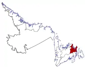 Lage der Region in Neufundland und Labrador | |
| Basisdaten | |
| Staat | Kanada |
| Provinz | Neufundland und Labrador |
| Koordinaten: | 48° 38′ N, 53° 2′ W |
| Einwohner | 34.092 (Stand: 2016) |
| Fläche | 9.672,91 km² |
| Bevölkerungsdichte | 3,5 Einw./km² |
| Zeitzone: | Newfoundland Standard Time (UTC−3:30) |
Die Census Division No. 7 erstreckt sich westlich der Avalon-Halbinsel entlang der Nordküste der Insel Neufundland. Sie hat eine Fläche von 9672,91 km². Beim Zensus 2016 lebten dort 34.092 Einwohner.[1] Beim Zensus 5 Jahre zuvor waren es noch 34.686. In der Census Division No. 7 befindet sich der Terra-Nova-Nationalpark.
Gemeinden (Towns)
- Bonavista
- Centreville-Wareham-Trinity
- Clarenville
- Dover
- Duntara
- Eastport
- Elliston
- Gambo
- Glovertown
- Greenspond
- Happy Adventure
- Hare Bay
- Indian Bay
- Keels
- King’s Cove
- Musgravetown
- New-Wes-Valley
- Port Blandford
- Port Rexton
- Salvage
- Sandringham
- Savage Cove-Sandy Cove
- St. Brendan’s
- Traytown
- Trinity (Trinity Bay)
- Trinity Bay North
Einzelnachweise
- Division No. 7, Census 2016. Statistics Canada. Abgerufen am 3. Oktober 2018.
This article is issued from Wikipedia. The text is licensed under Creative Commons - Attribution - Sharealike. The authors of the article are listed here. Additional terms may apply for the media files, click on images to show image meta data.