Newfoundland and Labrador Census Division No. 2
Die Census Division No. 2 ist eine Verwaltungseinheit in der kanadischen Provinz Neufundland und Labrador.
| Division No. 2 | |
|---|---|
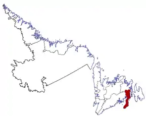 Lage der Region in Neufundland und Labrador | |
| Basisdaten | |
| Staat | Kanada |
| Provinz | Neufundland und Labrador |
| Koordinaten: | 47° 22′ N, 54° 54′ W |
| Einwohner | 20.372 (Stand: 2016) |
| Fläche | 6.099,08 km² |
| Bevölkerungsdichte | 3,3 Einw./km² |
| Zeitzone: | Newfoundland Standard Time (UTC−3:30) |
Die Census Division No. 2 erstreckt sich über die Burin-Halbinsel und das anliegende Gebiet auf der Insel Neufundland. Sie hat eine Fläche von 6.099,08 km².[1] Beim Zensus 2016 lebten dort 20.372 Einwohner.[1] 5 Jahre zuvor betrug die Einwohnerzahl noch 21.351.[1]
Gemeinden (Towns)
- Baine Harbour
- Bay L’Argent
- Burin
- English Harbour East
- Fortune
- Fox Cove-Mortier
- Frenchman’s Cove
- Garnish
- Grand Bank
- Grand le Pierre
- Lamaline
- Lawn
- Lewin’s Cove
- Little Bay East
- Lord’s Cove
- Marystown
- Parkers Cove
- Point May
- Point au Gaul
- Red Harbour
- Rushoon
- St. Bernard’s-Jacques Fontaine
- St. Lawrence
- Terrenceville
- Winterland
Einzelnachweise
- Division No. 2, Census 2016. Statistics Canada. Abgerufen am 3. Oktober 2018.
This article is issued from Wikipedia. The text is licensed under Creative Commons - Attribution - Sharealike. The authors of the article are listed here. Additional terms may apply for the media files, click on images to show image meta data.