Montenay
Montenay ist eine französische Gemeinde mit 1.363 Einwohnern (Stand: 1. Januar 2019) im Département Mayenne in der Region Pays de la Loire; sie gehört zum Arrondissement Mayenne und zum Kanton Ernée. Die Einwohner werden Montenaysiens genannt.
| Montenay | ||
|---|---|---|
| ||
| Staat | Frankreich | |
| Region | Pays de la Loire | |
| Département (Nr.) | Mayenne (53) | |
| Arrondissement | Mayenne | |
| Kanton | Ernée | |
| Gemeindeverband | Ernée | |
| Koordinaten | 48° 17′ N, 0° 54′ W | |
| Höhe | 94–208 m | |
| Fläche | 37,71 km² | |
| Einwohner | 1.363 (1. Januar 2019) | |
| Bevölkerungsdichte | 36 Einw./km² | |
| Postleitzahl | 53500 | |
| INSEE-Code | 53155 | |
| Website | https://www.montenay.net/ | |
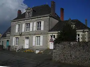 altes Rathaus (Mairie) von Montenay | ||

Geographie
Montenay liegt etwa 33 Kilometer nordnordwestlich von Laval. Umgeben wird Montenay von den Nachbargemeinden Ernée im Norden und Westen, Saint-Denis-de-Gastines im Norden und Nordosten, Vautorte im Osten, Chailland und Saint-Hilaire-du-Maine im Süden sowie Juvigné im Südwesten.
Bevölkerungsentwicklung
| Jahr | 1962 | 1968 | 1975 | 1982 | 1990 | 1999 | 2006 | 2013 |
| Einwohner | 1.181 | 1.084 | 1.156 | 1.354 | 1.433 | 1.399 | 1.416 | 1.361 |
| Quelle: Cassini und INSEE | ||||||||
Sehenswürdigkeiten
- Wetzstein (Polissoir) von La Berthelière, Monument historique
- Kirche Saint-Gervais und Saint-Protais
- Schloss La Bas Meignée aus dem 18. Jahrhundert
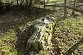 Polissoir
 Kirche Saint-Gervais und Saint-Protais
Literatur
- Le Patrimoine des Communes de la Mayenne. Flohic Editions, Band 1, Paris 2002, ISBN 2-84234-135-X, S. 342–344.
This article is issued from Wikipedia. The text is licensed under Creative Commons - Attribution - Sharealike. The authors of the article are listed here. Additional terms may apply for the media files, click on images to show image meta data.