Chantrigné
Chantrigné ist eine französische Gemeinde mit 606 Einwohnern (Stand: 1. Januar 2019) im Département Mayenne in der Region Pays de la Loire; sie gehört zum Mayenne und zum Kanton Gorron. Die Einwohner werden Chantrignéens genannt.
| Chantrigné | ||
|---|---|---|

|
| |
| Staat | Frankreich | |
| Region | Pays de la Loire | |
| Département (Nr.) | Mayenne (53) | |
| Arrondissement | Mayenne | |
| Kanton | Gorron | |
| Gemeindeverband | Bocage Mayennais | |
| Koordinaten | 48° 25′ N, 0° 34′ W | |
| Höhe | 97–285 m | |
| Fläche | 18,64 km² | |
| Einwohner | 606 (1. Januar 2019) | |
| Bevölkerungsdichte | 33 Einw./km² | |
| Postleitzahl | 53300 | |
| INSEE-Code | 53055 | |
| Website | http://www.chantrigne.mairie53.fr/ | |

Geographie
Chantrigné liegt etwa 46 Kilometer nordnordöstlich des Stadtzentrums von Laval. Umgeben wird Chantrigné von den Nachbargemeinden Ambrières-les-Vallées im Norden und Westen, Lassay-les-Châteaux im Norden und Osten, Le Horps im Südosten sowie Montreuil-Poulay und Saint-Loup-du-Gast im Süden.
Bevölkerungsentwicklung
| Jahr | 1962 | 1968 | 1975 | 1982 | 1990 | 1999 | 2006 | 2019 |
| Einwohner | 720 | 731 | 651 | 606 | 594 | 588 | 609 | 606 |
| Quellen: Cassini und INSEE | ||||||||
Sehenswürdigkeiten
- Menhir von Le Grand Coudray, seit 1976 Monument historique
- Allée couverte de la Hamelinière, seit 1932 Monument historique
- Kirche Saint-Pierre-Saint-Paul
 Menhir Le Grand Coudray
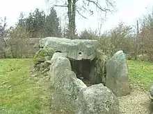 Allée couverte von La Hamelinière
 Kirche Saint-Pierre-Saint-Paul
Literatur
- Le Patrimoine des Communes de la Mayenne. Flohic Editions, Band 1, Paris 2002, ISBN 2-84234-135-X, S. 51–53.
This article is issued from Wikipedia. The text is licensed under Creative Commons - Attribution - Sharealike. The authors of the article are listed here. Additional terms may apply for the media files, click on images to show image meta data.