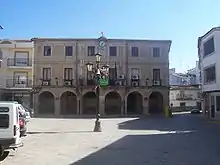
Montehermoso
Montehermoso ist eine spanische Stadt in der autonomen Region Extremadura. Montehermoso liegt in der Provinz Cáceres und zählt 5739 Einwohner (Stand 1. Januar 2019).
| Montehermoso | |||
|---|---|---|---|
| Wappen | Karte von Spanien | ||
 |
| ||
| Basisdaten | |||
| Autonome Gemeinschaft: | |||
| Provinz: | Cáceres | ||
| Comarca: | Vegas del Alagón | ||
| Koordinaten | 40° 5′ N, 6° 21′ W | ||
| Höhe: | 394 msnm | ||
| Fläche: | 96 km² | ||
| Einwohner: | 5.739 (1. Jan. 2019)[1] | ||
| Bevölkerungsdichte: | 59,78 Einw./km² | ||
| Postleitzahl: | E-10810 | ||
| Gemeindenummer (INE): | 10127 | ||
| Verwaltung | |||
| Bürgermeister: | María del Mar Mateos Garrido (PSOE) (Stand 2020) | ||
| Website: | www.montehermoso.org | ||
| Lage der Stadt | |||
Provinz Cáceres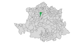 | |||

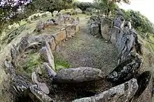
Der Dolmen del Tremedal und die Dolmen de la Gran Encina und Gran Dolmen liegen westlich von Montehermoso.
Weblinks
Einzelnachweise
- Cifras oficiales de población resultantes de la revisión del Padrón municipal a 1 de enero. Bevölkerungsstatistiken des Instituto Nacional de Estadística (Bevölkerungsfortschreibung).
Abadía | Abertura | Acebo | Acehúche | Aceituna | Ahigal | Alagón del Río | Albalá | Alcántara | Alcollarín | Alcuéscar | Aldea del Cano | La Aldea del Obispo | Aldeacentenera | Aldeanueva de la Vera | Aldeanueva del Camino | Aldehuela de Jerte | Alía | Aliseda | Almaraz | Almoharín | Arroyo de la Luz | Arroyomolinos | Arroyomolinos de la Vera | Baños de Montemayor | Barrado | Belvís de Monroy | Benquerencia | Berrocalejo | Berzocana | Bohonal de Ibor | Botija | Brozas | Cabañas del Castillo | Cabezabellosa | Cabezuela del Valle | Cabrero | Cáceres | Cachorrilla | Cadalso | Calzadilla | Caminomorisco | Campillo de Deleitosa | Campo Lugar | Cañamero | Cañaveral | Carbajo | Carcaboso | Carrascalejo | Casar de Cáceres | Casar de Palomero | Casares de las Hurdes | Casas de Don Antonio | Casas de Don Gómez | Casas de Millán | Casas de Miravete | Casas del Castañar | Casas del Monte | Casatejada | Casillas de Coria | Castañar de Ibor | Ceclavín | Cedillo | Cerezo | Cilleros | Collado | Conquista de la Sierra | Coria | Cuacos de Yuste | La Cumbre | Deleitosa | Descargamaría | Eljas | Escurial | Fresnedoso de Ibor | Galisteo | Garciaz | La Garganta | Garganta la Olla | Gargantilla | Gargüera | Garrovillas de Alconétar | Garvín | Gata | El Gordo | La Granja | Guadalupe | Guijo de Coria | Guijo de Galisteo | Guijo de Granadilla | Guijo de Santa Bárbara | Herguijuela | Hernán-Pérez | Herrera de Alcántara | Herreruela | Hervás | Higuera | Hinojal | Holguera | Hoyos | Huélaga | Ibahernando | Jaraicejo | Jaraíz de la Vera | Jarandilla de la Vera | Jarilla | Jerte | Ladrillar | Logrosán | Losar de la Vera | Madrigal de la Vera | Madrigalejo | Madroñera | Majadas | Malpartida de Cáceres | Malpartida de Plasencia | Marchagaz | Mata de Alcántara | Membrío | Mesas de Ibor | Miajadas | Millanes | Mirabel | Mohedas de Granadilla | Monroy | Montánchez | Montehermoso | Moraleja | Morcillo | Navaconcejo | Navalmoral de la Mata | Navalvillar de Ibor | Navas del Madroño | Navezuelas | Nuñomoral | Oliva de Plasencia | Palomero | Pasarón de la Vera | Pedroso de Acim | Peraleda de la Mata | Peraleda de San Román | Perales del Puerto | Pescueza | La Pesga | Piedras Albas | Pinofranqueado | Piornal | Plasencia | Plasenzuela | Portaje | Portezuelo | Pozuelo de Zarzón | Puerto de Santa Cruz | Rebollar | Riolobos | Robledillo de Gata | Robledillo de la Vera | Robledillo de Trujillo | Robledollano | Romangordo | Rosalejo | Ruanes | Salorino | Salvatierra de Santiago | San Martín de Trevejo | Santa Ana | Santa Cruz de la Sierra | Santa Cruz de Paniagua | Santa Marta de Magasca | Santiago de Alcántara | Santiago del Campo | Santibáñez el Alto | Santibáñez el Bajo | Saucedilla | Segura de Toro | Serradilla | Serrejón | Sierra de Fuentes | Talaván | Talaveruela de la Vera | Talayuela | Tejeda de Tiétar | Tiétar | Toril | Tornavacas | El Torno | Torre de Don Miguel | Torre de Santa María | Torrecilla de los Ángeles | Torrecillas de la Tiesa | Torrejón el Rubio | Torrejoncillo | Torremenga | Torremocha | Torreorgaz | Torrequemada | Trujillo | Valdastillas | Valdecañas de Tajo | Valdefuentes | Valdehúncar | Valdelacasa de Tajo | Valdemorales | Valdeobispo | Valencia de Alcántara | Valverde de la Vera | Valverde del Fresno | Viandar de la Vera | Vegaviana | Villa del Campo | Villa del Rey | Villamesías | Villamiel | Villanueva de la Sierra | Villanueva de la Vera | Villar de Plasencia | Villar del Pedroso | Villasbuenas de Gata | Zarza de Granadilla | Zarza de Montánchez | Zarza la Mayor | Zorita