Larré (Orne)
Larré ist eine französische Gemeinde mit 452 Einwohnern (Stand: 1. Januar 2019) im Département Orne in der Region Normandie. Larré gehört zum Arrondissement Alençon und zum Kanton Écouves (bis 2015: Kanton Alençon-3). Die Gemeinde ist Teil des Gemeindeverbandes Communauté urbaine d’Alençon. Die Einwohner werden Larrétois genannt.
| Larré | ||
|---|---|---|
| ||
| Staat | Frankreich | |
| Region | Normandie | |
| Département (Nr.) | Orne (61) | |
| Arrondissement | Alençon | |
| Kanton | Écouves | |
| Gemeindeverband | Communauté urbaine d’Alençon | |
| Koordinaten | 48° 30′ N, 0° 10′ O | |
| Höhe | 140–166 m | |
| Fläche | 5,63 km² | |
| Einwohner | 452 (1. Januar 2019) | |
| Bevölkerungsdichte | 80 Einw./km² | |
| Postleitzahl | 61250 | |
| INSEE-Code | 61224 | |

Geographie
Larré liegt etwa neun Kilometer nordöstlich von Alençon. Die Gemeinde gehört zum Regionalen Naturpark Normandie-Maine. Umgeben wird Larré von den Nachbargemeinden Ménil-Erreux im Norden und Osten, Hauterive im Südosten, Semallé im Süden und Südwesten sowie Écouves im Westen.
Bevölkerungsentwicklung
| Jahr | 1962 | 1968 | 1975 | 1982 | 1990 | 1999 | 2006 | 2013 |
|---|---|---|---|---|---|---|---|---|
| Einwohnerzahl | 210 | 206 | 257 | 326 | 365 | 384 | 403 | 423 |
| Quelle: Cassini und INSEE | ||||||||
Sehenswürdigkeiten
- Kirche Saint-Pierre aus dem 17. Jahrhundert
- Herrenhaus von La Cour
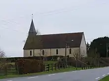
Kirche Saint-Pierre
This article is issued from Wikipedia. The text is licensed under Creative Commons - Attribution - Sharealike. The authors of the article are listed here. Additional terms may apply for the media files, click on images to show image meta data.