Saint-Gervais-du-Perron
Saint-Gervais-du-Perron ist eine Gemeinde im französischen Département Orne in der Normandie. Sie gehört zum Kanton Sées und zum Arrondissement Alençon.
| Saint-Gervais-du-Perron | ||
|---|---|---|
| ||
| Staat | Frankreich | |
| Region | Normandie | |
| Département (Nr.) | Orne (61) | |
| Arrondissement | Alençon | |
| Kanton | Sées | |
| Gemeindeverband | Communauté de communes des Sources de l’Orne | |
| Koordinaten | 48° 32′ N, 0° 10′ O | |
| Höhe | 151–333 m | |
| Fläche | 11,37 km² | |
| Einwohner | 361 (1. Januar 2019) | |
| Bevölkerungsdichte | 32 Einw./km² | |
| Postleitzahl | 61500 | |
| INSEE-Code | 61400 | |

Lage
Sie grenzt im Nordwesten an Le Bouillon, im Norden an La Chapelle-près-Sées, im Nordosten an Neauphe-sous-Essai, im Osten an Bursard, im Südosten an Ménil-Erreux und im Südwesten an Écouves. Die Gemeinde liegt im Regionalen Naturpark Normandie-Maine. Das Gemeindegebiet wird vom Fluss Vandre durchquert.
Bevölkerungsentwicklung
| Jahr | 1962 | 1968 | 1975 | 1982 | 1990 | 1999 | 2008 | 2015 |
|---|---|---|---|---|---|---|---|---|
| Einwohner | 297 | 227 | 222 | 249 | 293 | 283 | 320 | 386 |
Sehenswürdigkeiten
- Kirche Saint-Gervais-Saint-Protais
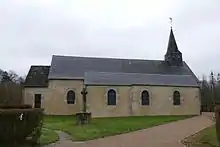
Kirche Saint-Gervais-Saint-Protais
This article is issued from Wikipedia. The text is licensed under Creative Commons - Attribution - Sharealike. The authors of the article are listed here. Additional terms may apply for the media files, click on images to show image meta data.