Laferté-sur-Amance
Laferté-sur-Amance ist eine französische Gemeinde mit 105 Einwohnern (Stand: 1. Januar 2019) im Département Haute-Marne in der Region Grand Est (vor 2016 Champagne-Ardenne); sie gehört zum Arrondissement Langres und zum Kanton Chalindrey.
| Laferté-sur-Amance | ||
|---|---|---|

|
| |
| Staat | Frankreich | |
| Region | Grand Est | |
| Département (Nr.) | Haute-Marne (52) | |
| Arrondissement | Langres | |
| Kanton | Chalindrey | |
| Gemeindeverband | Pays de Chalindrey, de Vannier Amance et de la Région de Bourbonne-les-Bains | |
| Koordinaten | 47° 50′ N, 5° 42′ O | |
| Höhe | 229–358 m | |
| Fläche | 8,00 km² | |
| Einwohner | 105 (1. Januar 2019) | |
| Bevölkerungsdichte | 13 Einw./km² | |
| Postleitzahl | 52500 | |
| INSEE-Code | 52257 | |

Geografie
Laferté-sur-Amance liegt rund 55 Kilometer südöstlich der Stadt Chaumont an der Amance. Umgeben wird Laferté-sur-Amance von den Nachbargemeinden Guyonvelle im Norden, Velles im Osten, Ouge im Süden und Südosten, Pierremont-sur-Amance im Südwesten sowie Anrosey im Westen.
Bevölkerungsentwicklung
| Jahr | 1962 | 1968 | 1975 | 1982 | 1990 | 1999 | 2006 | 2018 | ||||||
| Einwohner | 298 | 257 | 421 | 375 | 171 | 150 | 118 | 107 | ||||||
| Quellen: Cassini und INSEE | ||||||||||||||
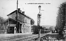
alte Postkarte des Bahnhofes
This article is issued from Wikipedia. The text is licensed under Creative Commons - Attribution - Sharealike. The authors of the article are listed here. Additional terms may apply for the media files, click on images to show image meta data.