Chalancey
Chalancey ist eine französische Gemeinde mit 105 Einwohnern (Stand: 1. Januar 2019) im Département Haute-Marne in der Region Grand Est. Sie gehört zum Arrondissement Langres und zum Kanton Villegusien-le-Lac.
| Chalancey | ||
|---|---|---|
.svg.png.webp)
|
| |
| Staat | Frankreich | |
| Region | Grand Est | |
| Département (Nr.) | Haute-Marne (52) | |
| Arrondissement | Langres | |
| Kanton | Villegusien-le-Lac | |
| Gemeindeverband | Auberive Vingeanne et Montsaugeonnais | |
| Koordinaten | 47° 41′ N, 5° 8′ O | |
| Höhe | 341–478 m | |
| Fläche | 13,64 km² | |
| Einwohner | 105 (1. Januar 2019) | |
| Bevölkerungsdichte | 8 Einw./km² | |
| Postleitzahl | 52160 | |
| INSEE-Code | 52092 | |
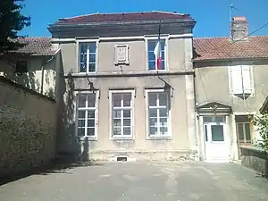 Mairie Chalancey | ||

Geografie
Die Gemeinde Chalancey liegt an der Venelle, 28 Kilometer südwestlich von Langres an der Grenze zum Département Côte-d’Or. Sie ist umgeben von folgenden Nachbargemeinden:
| Mouilleron | Vaillant | Vesvres-sous-Chalancey |
| Vals-des-Tilles | .svg.png.webp) |
Vernois-lès-Vesvres |
| Cussey-les-Forges | Vernois-lès-Vesvres |
Bevölkerungsentwicklung
| Jahr | 1962 | 1968 | 1975 | 1982 | 1990 | 1999 | 2008 | 2018 | |
|---|---|---|---|---|---|---|---|---|---|
| Einwohner | 185 | 172 | 159 | 133 | 124 | 132 | 129 | 106 | |
| Quellen: Cassini und INSEE | |||||||||
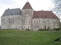 Schloss von Chalancey, Monument historique
.jpg.webp) Kirche Sainte-Madeleine, Monument historique
Kirche Sainte-Madeleine, Monument historique
This article is issued from Wikipedia. The text is licensed under Creative Commons - Attribution - Sharealike. The authors of the article are listed here. Additional terms may apply for the media files, click on images to show image meta data.