Kanton Montataire
Der Kanton Montataire ist ein französischer Wahlkreis in den Arrondissements Clermont und Senlis, im Département Oise und in der Region Hauts-de-France; sein Hauptort ist Montataire. Vertreter im Generalrat des Départements ist seit 1994 Alain Blanchard (PCF).
| Kanton Montataire | |
|---|---|
| Region | Hauts-de-France |
| Département | Oise |
| Arrondissement | Clermont (1 Gemeinde) Senlis (14 Gemeinden) |
| Hauptort | Montataire |
| Einwohner | 36.881 (1. Jan. 2019) |
| Bevölkerungsdichte | 303 Einw./km² |
| Fläche | 121,66 km² |
| Gemeinden | 15 |
| INSEE-Code | 6013 |
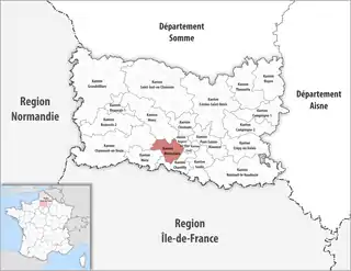
 Lage des Kantons Montataire im Département Oise | |
Gemeinden
Der Kanton besteht aus 15 Gemeinden mit insgesamt 36.881 Einwohnern (Stand: 1. Januar 2019) auf einer Gesamtfläche von 121,66 km²:
| Gemeinde | Einwohner 1. Januar 2019 |
Fläche km² |
Dichte Einw./km² |
Code INSEE |
Postleitzahl | Arrondissement |
|---|---|---|---|---|---|---|
| Balagny-sur-Thérain | 1.682 | 6,82 | 247 | 60044 | 60250 | Senlis |
| Blaincourt-lès-Précy | 1.185 | 8,30 | 143 | 60074 | 60460 | Senlis |
| Cires-lès-Mello | 3.996 | 16,83 | 237 | 60155 | 60660 | Senlis |
| Cramoisy | 810 | 6,36 | 127 | 60173 | 60660 | Senlis |
| Foulangues | 199 | 5,20 | 38 | 60249 | 60250 | Senlis |
| Maysel | 230 | 3,78 | 61 | 60391 | 60660 | Senlis |
| Mello | 613 | 3,36 | 182 | 60393 | 60660 | Senlis |
| Montataire | 13.645 | 10,61 | 1.286 | 60414 | 60160 | Senlis |
| Précy-sur-Oise | 3.220 | 9,85 | 327 | 60513 | 60460 | Senlis |
| Rousseloy | 299 | 3,93 | 76 | 60551 | 60660 | Clermont |
| Saint-Leu-d’Esserent | 4.678 | 13,21 | 354 | 60584 | 60340 | Senlis |
| Saint-Vaast-lès-Mello | 1.041 | 7,94 | 131 | 60601 | 60660 | Senlis |
| Thiverny | 1.075 | 2,09 | 514 | 60635 | 60160 | Senlis |
| Ully-Saint-Georges | 1.890 | 18,75 | 101 | 60651 | 60730 | Senlis |
| Villers-sous-Saint-Leu | 2.318 | 4,63 | 501 | 60686 | 60340 | Senlis |
| Kanton Montataire | 36.881 | 121,66 | 303 | 6013 | – | – |
Bis zur Neuordnung bestand der Kanton Montataire aus den 10 Gemeinden Blaincourt-lès-Précy, Cramoisy, Maysel, Mello, Montataire, Précy-sur-Oise, Saint-Leu-d’Esserent, Saint-Vaast-lès-Mello, Thiverny und Villers-sous-Saint-Leu. Sein Zuschnitt entsprach einer Fläche von 69,28 km2.
Bevölkerungsentwicklung
| 1962 | 1968 | 1975 | 1982 | 1990 | 1999 | 2006 | 2011 |
|---|---|---|---|---|---|---|---|
| 18.669 | 20.422 | 24.965 | 26.033 | 26.589 | 26.376 | 26.704 | 27.708 |
This article is issued from Wikipedia. The text is licensed under Creative Commons - Attribution - Sharealike. The authors of the article are listed here. Additional terms may apply for the media files, click on images to show image meta data.