Kanton Guérigny
Der Kanton Guérigny ist ein französischer Wahlkreis im Arrondissement Nevers im Département Nièvre und in der Region Bourgogne-Franche-Comté; sein Hauptort ist Guérigny, Vertreter im Generalrat des Départements war von 2001 bis 2015 Pascal Reuillard (PCF).
| Kanton Guérigny | |
|---|---|
| Region | Bourgogne-Franche-Comté |
| Département | Nièvre |
| Arrondissement | Nevers |
| Hauptort | Guérigny |
| Einwohner | 14.081 (1. Jan. 2019) |
| Bevölkerungsdichte | 19 Einw./km² |
| Fläche | 756,09 km² |
| Gemeinden | 32 |
| INSEE-Code | 5808 |
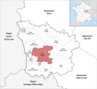 Lage des Kantons Guérigny im Département Nièvre | |
Gemeinden
Der Kanton besteht aus 32 Gemeinden mit insgesamt 14.081 Einwohnern (Stand: 1. Januar 2019) auf einer Gesamtfläche von 756,09 km²:
| Gemeinde | Einwohner 1. Januar 2019 |
Fläche km² |
Dichte Einw./km² |
Code INSEE |
Postleitzahl |
|---|---|---|---|---|---|
| Anlezy | 244 | 21,51 | 11 | 58006 | 58270 |
| Bazolles | 280 | 28,64 | 10 | 58024 | 58110 |
| Beaumont-Sardolles | 117 | 29,53 | 4 | 58028 | 58270 |
| Billy-Chevannes | 299 | 23,88 | 13 | 58031 | 58270 |
| Bona | 302 | 23,47 | 13 | 58035 | 58330 |
| Cizely | 54 | 7,13 | 8 | 58078 | 58270 |
| Crux-la-Ville | 395 | 45,89 | 9 | 58092 | 58330 |
| Diennes-Aubigny | 92 | 37,38 | 2 | 58097 | 58340 |
| Fertrève | 98 | 24,79 | 4 | 58113 | 58270 |
| Frasnay-Reugny | 82 | 13,90 | 6 | 58119 | 58270 |
| Guérigny | 2.510 | 7,44 | 337 | 58131 | 58130 |
| Jailly | 68 | 11,01 | 6 | 58136 | 58330 |
| La Fermeté | 632 | 35,56 | 18 | 58112 | 58160 |
| Limon | 144 | 8,13 | 18 | 58143 | 58270 |
| Montigny-aux-Amognes | 634 | 25,09 | 25 | 58176 | 58130 |
| Nolay | 347 | 42,88 | 8 | 58196 | 58700 |
| Poiseux | 328 | 30,57 | 11 | 58212 | 58130 |
| Rouy | 630 | 35,92 | 18 | 58223 | 58110 |
| Saint-Benin-d’Azy | 1.265 | 36,17 | 35 | 58232 | 58270 |
| Saint-Benin-des-Bois | 166 | 19,57 | 8 | 58233 | 58330 |
| Saint-Firmin | 159 | 10,57 | 15 | 58239 | 58270 |
| Saint-Franchy | 77 | 18,82 | 4 | 58240 | 58330 |
| Saint-Jean-aux-Amognes | 484 | 18,26 | 27 | 58247 | 58270 |
| Saint-Martin-d’Heuille | 570 | 13,49 | 42 | 58254 | 58130 |
| Saint-Maurice | 64 | 10,46 | 6 | 58257 | 58330 |
| Saint-Saulge | 724 | 26,19 | 28 | 58267 | 58330 |
| Saint-Sulpice | 413 | 25,78 | 16 | 58269 | 58270 |
| Sainte-Marie | 78 | 15,62 | 5 | 58253 | 58330 |
| Saxi-Bourdon | 297 | 18,65 | 16 | 58275 | 58330 |
| Urzy | 1.746 | 23,85 | 73 | 58300 | 58130 |
| Vaux d’Amognes | 540 | 38,72 | 14 | 58204 | 58130 |
| Ville-Langy | 242 | 27,22 | 9 | 58311 | 58270 |
| Kanton Guérigny | 14.081 | 756,09 | 19 | 5808 | – |
Bis zur landesweiten Neuordnung der französischen Kantone im März 2015 gehörten zum Kanton Guérigny die acht Gemeinden Balleray, Guérigny, Nolay, Ourouër, Poiseux, Saint-Martin-d’Heuille, Urzy und Varennes-Vauzelles. Sein Zuschnitt entsprach einer Fläche von 189,13 km2. Er besaß vor 2015 einen anderen INSEE-Code als heute, nämlich 5826.
Veränderungen im Gemeindebestand seit der landesweiten Neuordnung der Kantone
2017: Fusion Balleray und Ourouër → Vaux d’Amognes
Bevölkerungsentwicklung
| Jahr | 1962 | 1968 | 1975 | 1982 | 1990 | 1999 | 2006 | ||
|---|---|---|---|---|---|---|---|---|---|
| Einwohner | 11.795 | 13.711 | 13.689 | 15.516 | 16.443 | 16.258 | 15.755 | ||
| Quellen: Cassini und INSEE | |||||||||