Kanton Dompaire
Der Kanton Dompaire war bis 2015 ein französischer Kanton im Arrondissement Épinal, im Département Vosges und in der Region Lothringen; sein Hauptort war Dompaire. Letzter Vertreter im Generalrat des Départements war von 2011 bis 2015 Gérard Marulier (DVD).
| Ehemaliger Kanton Dompaire | |
|---|---|
| Region | Lothringen |
| Département | Vosges |
| Arrondissement | Épinal |
| Hauptort | Dompaire |
| Auflösungsdatum | 29. März 2015 |
| Einwohner | 5.981 (1. Jan. 2012) |
| Bevölkerungsdichte | 27 Einw./km² |
| Fläche | 223 km² |
| Gemeinden | 30 |
| INSEE-Code | 8811 |
Lage
Der Kanton lag im Zentrum des Départements Vosges.
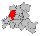 Lage des Kantons Dompaire innerhalb des Arrondissements Épinal
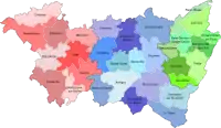 Lage des Kantons Dompaire innerhalb des Départements Vosges
Gemeinden
Der Kanton bestand aus dreißig Gemeinden:
| Gemeinde | Einwohner Jahr | Fläche km² | Bevölkerungsdichte | Code INSEE | Postleitzahl |
|---|---|---|---|---|---|
| Les Ableuvenettes | 76 (2013) | 4,49 | 17 Einw./km² | 88001 | 88270 |
| Ahéville | 57 (2013) | 5,84 | 10 Einw./km² | 88002 | 88500 |
| Bainville-aux-Saules | 132 (2013) | 5,61 | 24 Einw./km² | 88030 | 88270 |
| Bazegney | 115 (2013) | 5,81 | 20 Einw./km² | 88041 | 88270 |
| Begnécourt | 171 (2013) | 4,57 | 37 Einw./km² | 88047 | 88270 |
| Bettegney-Saint-Brice | 156 (2013) | 5,32 | 29 Einw./km² | 88055 | 88450 |
| Bocquegney | 124 (2013) | 4,57 | 27 Einw./km² | 88063 | 88270 |
| Bouxières-aux-Bois | 137 (2013) | 7,68 | 18 Einw./km² | 88069 | 88270 |
| Bouzemont | 57 (2013) | 4,97 | 11 Einw./km² | 88071 | 88270 |
| Circourt | 77 (2013) | 5,93 | 13 Einw./km² | 88103 | 88270 |
| Damas-et-Bettegney | 367 (2013) | 15,07 | 24 Einw./km² | 88122 | 88270 |
| Derbamont | 94 (2013) | 6,83 | 14 Einw./km² | 88129 | 88270 |
| Dompaire | 1.139 (2013) | 16,63 | 68 Einw./km² | 88151 | 88270 |
| Gelvécourt-et-Adompt | 100 (2013) | 3,94 | 25 Einw./km² | 88192 | 88270 |
| Gorhey | 177 (2013) | 6,31 | 28 Einw./km² | 88210 | 88270 |
| Gugney-aux-Aulx | 149 (2013) | 8,67 | 17 Einw./km² | 88223 | 88450 |
| Hagécourt | 114 (2013) | 7,6 | 15 Einw./km² | 88226 | 88270 |
| Harol | 610 (2013) | 27,34 | 22 Einw./km² | 88233 | 88270 |
| Hennecourt | 353 (2013) | 7,17 | 49 Einw./km² | 88237 | 88270 |
| Jorxey | 87 (2013) | 5,4 | 16 Einw./km² | 88254 | 88500 |
| Légéville-et-Bonfays | 48 (2013) | 5,21 | 9 Einw./km² | 88264 | 88270 |
| Madegney | 101 (2013) | 3,05 | 33 Einw./km² | 88280 | 88450 |
| Madonne-et-Lamerey | 375 (2013) | 7,02 | 53 Einw./km² | 88281 | 88270 |
| Maroncourt | 12 (2013) | 2,24 | 5 Einw./km² | 88288 | 88270 |
| Racécourt | 162 (2013) | 7,23 | 22 Einw./km² | 88365 | 88270 |
| Regney | 88 (2013) | 3,9 | 23 Einw./km² | 88378 | 88450 |
| Saint-Vallier | 111 (2013) | 4,44 | 25 Einw./km² | 88437 | 88270 |
| Vaubexy | 127 (2013) | 6,52 | 19 Einw./km² | 88494 | 88500 |
| Velotte-et-Tatignécourt | 149 (2013) | 5,36 | 28 Einw./km² | 88499 | 88270 |
| Ville-sur-Illon | 543 (2013) | 17,89 | 30 Einw./km² | 88508 | 88270 |
Bevölkerungsentwicklung
| 1962 | 1968 | 1975 | 1982 | 1990 | 1999 | 2006 | 2012 |
|---|---|---|---|---|---|---|---|
| 6.037 | 5.650 | 5.092 | 4.961 | 5.150 | 5.299 | 5.607 | 5.981 |
This article is issued from Wikipedia. The text is licensed under Creative Commons - Attribution - Sharealike. The authors of the article are listed here. Additional terms may apply for the media files, click on images to show image meta data.