Kanton Monthureux-sur-Saône
Der Kanton Monthureux-sur-Saône war bis 2015 ein französischer Wahlkreis im Arrondissement Neufchâteau im Département Vosges und in der Region Lothringen; sein Hauptort war Monthureux-sur-Saône.
| Ehemaliger Kanton Monthureux-sur-Saône | |
|---|---|
| Region | Lothringen |
| Département | Vosges |
| Arrondissement | Neufchâteau |
| Hauptort | Monthureux-sur-Saône |
| Auflösungsdatum | 29. März 2015 |
| Einwohner | 2.447 (1. Jan. 2012) |
| Bevölkerungsdichte | 18 Einw./km² |
| Fläche | 139.21 km² |
| Gemeinden | 11 |
| INSEE-Code | 8817 |
Lage
Der Kanton lag im Südwesten des Départements Vosges.
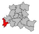 Lage des Kantons Monthureux-sur-Saône innerhalb des Arrondissements Neufchâteau
 Lage des Kantons Monthureux-sur-Saône innerhalb des Départements Vosges
Gemeinden
Der Kanton bestand aus elf Gemeinden:
| Gemeinde | Einwohner Jahr | Fläche km² | Bevölkerungsdichte | Code INSEE | Postleitzahl |
|---|---|---|---|---|---|
| Ameuvelle | 56 (2013) | 5,56 | 10 Einw./km² | 88007 | 88410 |
| Bleurville | 353 (2013) | 20,25 | 17 Einw./km² | 88061 | 88410 |
| Claudon | 218 (2013) | 21,72 | 10 Einw./km² | 88105 | 88410 |
| Fignévelle | 52 (2013) | 4,4 | 12 Einw./km² | 88171 | 88410 |
| Gignéville | 77 (2013) | 5,58 | 14 Einw./km² | 88199 | 88320 |
| Godoncourt | 139 (2013) | 11,38 | 12 Einw./km² | 88208 | 88410 |
| Martinvelle | 120 (2013) | 24,73 | 5 Einw./km² | 88291 | 88410 |
| Monthureux-sur-Saône | 878 (2013) | 19,02 | 46 Einw./km² | 88310 | 88410 |
| Nonville | 213 (2013) | 8,91 | 24 Einw./km² | 88330 | 88260 |
| Regnévelle | 130 (2013) | 8,62 | 15 Einw./km² | 88377 | 88410 |
| Viviers-le-Gras | 180 (2013) | 9,04 | 20 Einw./km² | 88517 | 88260 |
Bevölkerungsentwicklung
| 1962 | 1968 | 1975 | 1982 | 1990 | 1999 | 2006 | 2012 |
|---|---|---|---|---|---|---|---|
| 3.322 | 3.295 | 3.074 | 2.948 | 2.764 | 2.614 | 2.442 | 2.447 |
This article is issued from Wikipedia. The text is licensed under Creative Commons - Attribution - Sharealike. The authors of the article are listed here. Additional terms may apply for the media files, click on images to show image meta data.