Générac (Gironde)
Générac ist eine französische Gemeinde mit 541 Einwohnern (Stand: 1. Januar 2019) im Département Gironde in der Region Nouvelle-Aquitaine. Die Gemeinde gehört zum Arrondissement Blaye und ist Teil des Kantons Le Nord-Gironde (bis 2015: Kanton Saint-Savin). Die Einwohner werden Généracais genannt.
| Générac | ||
|---|---|---|
| ||
| Staat | Frankreich | |
| Region | Nouvelle-Aquitaine | |
| Département (Nr.) | Gironde (33) | |
| Arrondissement | Blaye | |
| Kanton | Le Nord-Gironde | |
| Gemeindeverband | Blaye | |
| Koordinaten | 45° 11′ N, 0° 33′ W | |
| Höhe | 19–50 m | |
| Fläche | 9,53 km² | |
| Einwohner | 541 (1. Januar 2019) | |
| Bevölkerungsdichte | 57 Einw./km² | |
| Postleitzahl | 33920 | |
| INSEE-Code | 33184 | |
 Rathaus (Mairie) von Générac | ||

Geografie
Générac liegt etwa 37 Kilometer nördlich von Bordeaux. Umgeben wird Générac von den Nachbargemeinden Campugnan im Norden und Westen, Saugon im Osten und Nordosten, Saint-Girons-d’Aiguevives im Süden und Südosten sowie Saint-Paul im Südwesten.
Bevölkerungsentwicklung
| 1962 | 1968 | 1975 | 1982 | 1990 | 1999 | 2006 | 2017 |
|---|---|---|---|---|---|---|---|
| 551 | 486 | 438 | 460 | 465 | 493 | 563 | 541 |
| Quellen: Cassini und INSEE | |||||||
Sehenswürdigkeiten
- Kirche Saint-Genès
- Wehrhaus Le Prat aus dem 14. Jahrhundert, Monument historique seit 2002
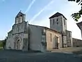 Kirche Saint-Louis
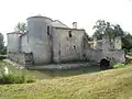 Wehrhaus Le Prat
Literatur
- Le Patrimoine des Communes de la Gironde. Flohic Éditions, Band 2, Paris 2001, ISBN 2-84234-125-2, S. 1377.
Weblinks
Commons: Générac – Sammlung von Bildern, Videos und Audiodateien
This article is issued from Wikipedia. The text is licensed under Creative Commons - Attribution - Sharealike. The authors of the article are listed here. Additional terms may apply for the media files, click on images to show image meta data.