Fours (Gironde)
Fours ist eine französische Gemeinde mit 287 Einwohnern (Stand 1. Januar 2019) im Département Gironde in der Region Nouvelle-Aquitaine. Sie gehört zum Arrondissement und zum Kanton L’Estuaire.
| Fours | ||
|---|---|---|
| ||
| Staat | Frankreich | |
| Region | Nouvelle-Aquitaine | |
| Département (Nr.) | Gironde (33) | |
| Arrondissement | Blaye | |
| Kanton | L’Estuaire | |
| Gemeindeverband | Blaye | |
| Koordinaten | 45° 10′ N, 0° 38′ W | |
| Höhe | 0–33 m | |
| Fläche | 4,67 km² | |
| Einwohner | 287 (1. Januar 2019) | |
| Bevölkerungsdichte | 61 Einw./km² | |
| Postleitzahl | 33390 | |
| INSEE-Code | 33172 | |
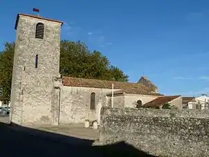 Pfarrkirche Saint-Louis | ||

Geografie
Das Gemeindegebiet von Fours grenzt im Westen an die Gironde.
Bevölkerungsentwicklung
| Jahr | 1962 | 1968 | 1975 | 1982 | 1990 | 1999 | 2006 | 2017 |
| Einwohner | 241 | 208 | 195 | 252 | 250 | 279 | 285 | 318 |
Sehenswürdigkeiten
- Pfarrkirche Saint-Louis
Literatur
- Le Patrimoine des Communes de la Gironde. Flohic Éditions, Band 1, Paris 2001, ISBN 2-84234-125-2, S. 225–226.
Weblinks
Commons: Fours – Sammlung von Bildern, Videos und Audiodateien
This article is issued from Wikipedia. The text is licensed under Creative Commons - Attribution - Sharealike. The authors of the article are listed here. Additional terms may apply for the media files, click on images to show image meta data.