Chaufour-lès-Bonnières
Chaufour-lès-Bonnières ist eine Gemeinde im französischen Département Yvelines in der Île-de-France. Sie gehört zum Kanton Bonnières-sur-Seine im Arrondissement Mantes-la-Jolie. Sie grenzt im Norden an Blaru, im Nordosten an La Villeneuve-en-Chevrie, im Südosten an Lommoye, im Süden an Cravent, im Südwesten an Villegats und im Westen an Chaignes. Die Bewohner nennen sich Chaufouriens.
| Chaufour-lès-Bonnières | ||
|---|---|---|
.svg.png.webp)
|
| |
| Staat | Frankreich | |
| Region | Île-de-France | |
| Département (Nr.) | Yvelines (78) | |
| Arrondissement | Mantes-la-Jolie | |
| Kanton | Bonnières-sur-Seine | |
| Gemeindeverband | Portes de l’Île-de-France | |
| Koordinaten | 49° 1′ N, 1° 29′ O | |
| Höhe | 133–158 m | |
| Fläche | 3,01 km² | |
| Einwohner | 476 (1. Januar 2019) | |
| Bevölkerungsdichte | 158 Einw./km² | |
| Postleitzahl | 78270 | |
| INSEE-Code | 78147 | |

Bevölkerungsentwicklung
| Jahr | 1962 | 1968 | 1975 | 1982 | 1990 | 1999 | 2008 | 2014 |
|---|---|---|---|---|---|---|---|---|
| Einwohner | 140 | 150 | 185 | 300 | 376 | 413 | 412 | 448 |
Sehenswürdigkeiten
- Kriegerdenkmal
- Kirche Saint-Sauveur
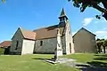 Kirche Saint-Sauveur und Kriegerdenkmal
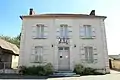 Mairie Chaufour-lès-Bonnières
Literatur
- Le Patrimoine des Communes des Yvelines. Band 1, Flohic Editions, Paris 2000, ISBN 2-84234-070-1, S. 99–100.
Weblinks
Commons: Chaufour-lès-Bonnières – Sammlung von Bildern, Videos und Audiodateien
- Monuments historiques (Objekte) in Chaufour-lès-Bonnières in der Base Palissy des französischen Kultusministeriums
This article is issued from Wikipedia. The text is licensed under Creative Commons - Attribution - Sharealike. The authors of the article are listed here. Additional terms may apply for the media files, click on images to show image meta data.