Fontenay-Saint-Père
| Fontenay-Saint-Père | ||
|---|---|---|

|
| |
| Staat | Frankreich | |
| Region | Île-de-France | |
| Département (Nr.) | Yvelines (78) | |
| Arrondissement | Mantes-la-Jolie | |
| Kanton | Limay | |
| Gemeindeverband | Grand Paris Seine et Oise | |
| Koordinaten | 49° 2′ N, 1° 45′ O | |
| Höhe | 67–196 m | |
| Fläche | 13,06 km² | |
| Einwohner | 954 (1. Januar 2019) | |
| Bevölkerungsdichte | 73 Einw./km² | |
| Postleitzahl | 78440 | |
| INSEE-Code | 78246 | |
| Website | https://www.fontenay-saint-pere.fr/ | |
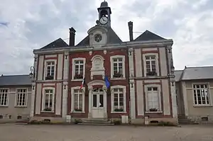 Rathaus (Mairie) von Fontenay-Saint-Père | ||

Fontenay-Saint-Père ist eine französische Gemeinde mit 954 Einwohnern (Stand: 1. Januar 2019) im Département Yvelines in der Region Île-de-France. Sie gehört zum Arrondissement Mantes-la-Jolie und zum Kanton Limay. Die Einwohner nennen sich Fontenaysiens.
Geografie
Fontenay-Saint-Père liegt etwa 47 Kilometer westnordwestlich von Paris im Tal der Seine. Fontenay-Saint-Père wird umgeben von den Nachbargemeinden Saint-Cyr-en-Arthies im Norden, Drocourt im Norden und Nordosten, Sailly im Nordosten, Brueil-en-Vexin im Osten, Guitrancourt im Südosten, Limay im Süden sowie Follainville-Dennemont im Westen.
Bevölkerungsentwicklung
| 1962 | 1968 | 1975 | 1982 | 1990 | 1999 | 2006 | 2012 | |
|---|---|---|---|---|---|---|---|---|
| 706 | 758 | 782 | 808 | 927 | 987 | 886 | 990 | |
| Quellen: Cassini und INSEE | ||||||||
Sehenswürdigkeiten
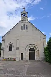
Kirche Saint-Denis
Siehe auch: Liste der Monuments historiques in Fontenay-Saint-Père
- Kirche Saint-Denis, im 12. Jahrhundert erbaut, Fassade rekonstruiert 1885
Persönlichkeiten
- Jean-Martial Frédou (1710–1795), Maler
Literatur
- Le Patrimoine des Communes des Yvelines. Band 1, Flohic Editions, Paris 2000, ISBN 2-84234-070-1, S. 369–370.
This article is issued from Wikipedia. The text is licensed under Creative Commons - Attribution - Sharealike. The authors of the article are listed here. Additional terms may apply for the media files, click on images to show image meta data.