Villars-les-Bois
Villars-les-Bois ist ein Ort und eine westfranzösische Gemeinde mit 232 Einwohnern (Stand: 1. Januar 2019) im Département Charente-Maritime in der Region Nouvelle-Aquitaine. Die Gemeinde gehört zum Arrondissement Saintes und zum Kanton Chaniers (bis 2015: Kanton Burie). Die Einwohner werden Villarboisiens genannt.
| Villars-les-Bois | ||
|---|---|---|
| ||
| Staat | Frankreich | |
| Region | Nouvelle-Aquitaine | |
| Département (Nr.) | Charente-Maritime (17) | |
| Arrondissement | Saintes | |
| Kanton | Chaniers | |
| Gemeindeverband | Saintes | |
| Koordinaten | 45° 49′ N, 0° 26′ W | |
| Höhe | 17–101 m | |
| Fläche | 8,62 km² | |
| Einwohner | 232 (1. Januar 2019) | |
| Bevölkerungsdichte | 27 Einw./km² | |
| Postleitzahl | 17770 | |
| INSEE-Code | 17470 | |
| Website | https://www.communevillarslesbois.fr/ | |
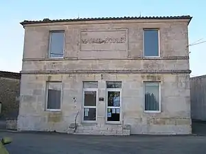 Rathaus (Mairie) von Villars-les-Bois | ||

Lage
Villars-les-Bois liegt in der Saintonge etwa 16 Kilometer ostnordöstlich von Saintes. Umgeben wird Villars-les-Bois von den Nachbargemeinden Migron im Norden und Osten, Burie im Süden, Saint-Bris-des-Bois im Südwesten sowie Brizambourg im Westen und Nordwesten.
Bevölkerungsentwicklung
| Jahr | 1962 | 1968 | 1975 | 1982 | 1990 | 1999 | 2008 | 2017 |
| Einwohner | 290 | 313 | 281 | 263 | 256 | 256 | 248 | 246 |
| Quellen: Cassini und INSEE | ||||||||
Sehenswürdigkeiten
- Kirche Saint-Victorin aus dem 12. Jahrhundert, seit 1912 Monument historique
Siehe auch: Liste der Monuments historiques in Villars-les-Bois
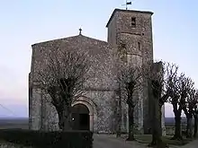
Kirche Saint-Victorin
Literatur
- Le Patrimoine des Communes de la Charente-Maritime. Flohic Editions, Band 1, Paris 2002, ISBN 2-84234-129-5, S. 185.
This article is issued from Wikipedia. The text is licensed under Creative Commons - Attribution - Sharealike. The authors of the article are listed here. Additional terms may apply for the media files, click on images to show image meta data.