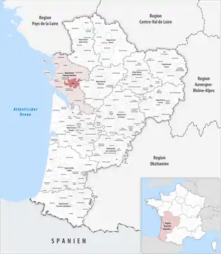
Communauté d’agglomération de Saintes
Die Communauté d’agglomération de Saintes ist ein französischer Gemeindeverband mit der Rechtsform einer Communauté d’agglomération im Département Charente-Maritime in der Region Nouvelle-Aquitaine. Sie wurde am 28. Dezember 2012 gegründet und umfasst 36 Gemeinden. Der Verwaltungssitz befindet sich in der Stadt Saintes.[2]
| Communauté d’agglomération de Saintes | |
| Region(en) | Nouvelle-Aquitaine |
| Département(s) | Charente-Maritime |
| Gründungsdatum | 28. Dezember 2012 |
| Rechtsform | Communauté d’agglomération |
| Verwaltungssitz | Saintes |
| Gemeinden | 36 |
| Präsident | Jean-Philippe Machon |
| SIREN-Nummer | 200 036 473 |
| Fläche | 476,43 km² |
| Einwohner | 60.110 (2019)[1] |
| Bevölkerungsdichte | 126 Einw./km² |
| Website | https://www.agglo-saintes.fr/ |
 Lage des Gemeindeverbandes in der Region Nouvelle-Aquitaine | |
Mitgliedsgemeinden
| Gemeinde | Einwohner 1. Januar 2019 |
Fläche km² |
Dichte Einw./km² |
Code INSEE |
Postleitzahl |
|---|---|---|---|---|---|
| Burie | 1.303 | 9,26 | 141 | 17072 | 17770 |
| Bussac-sur-Charente | 1.277 | 10,11 | 126 | 17073 | 17100 |
| Chaniers | 3.587 | 26,53 | 135 | 17086 | 17610 |
| Chérac | 1.118 | 29,91 | 37 | 17100 | 17610 |
| Chermignac | 1.263 | 13,52 | 93 | 17102 | 17460 |
| Colombiers | 309 | 7,23 | 43 | 17115 | 17460 |
| Corme-Royal | 1.878 | 27,17 | 69 | 17120 | 17600 |
| Courcoury | 694 | 12,73 | 55 | 17128 | 17100 |
| Dompierre-sur-Charente | 470 | 8,31 | 57 | 17141 | 17610 |
| Écoyeux | 1.376 | 20,46 | 67 | 17147 | 17770 |
| Écurat | 459 | 10,55 | 44 | 17148 | 17810 |
| Fontcouverte | 2.326 | 11,77 | 198 | 17164 | 17100 |
| La Chapelle-des-Pots | 1.004 | 10,27 | 98 | 17089 | 17100 |
| La Clisse | 713 | 5,24 | 136 | 17112 | 17600 |
| La Jard | 427 | 8,50 | 50 | 17191 | 17460 |
| Le Douhet | 703 | 18,51 | 38 | 17143 | 17100 |
| Le Seure | 252 | 5,38 | 47 | 17426 | 17770 |
| Les Gonds | 1.772 | 13,04 | 136 | 17179 | 17100 |
| Luchat | 536 | 4,71 | 114 | 17214 | 17600 |
| Migron | 721 | 14,98 | 48 | 17235 | 17770 |
| Montils | 869 | 23,88 | 36 | 17242 | 17800 |
| Pessines | 774 | 9,14 | 85 | 17275 | 17810 |
| Pisany | 761 | 6,66 | 114 | 17278 | 17600 |
| Préguillac | 445 | 6,65 | 67 | 17289 | 17460 |
| Rouffiac | 478 | 5,91 | 81 | 17304 | 17800 |
| Saint-Bris-des-Bois | 381 | 9,04 | 42 | 17313 | 17770 |
| Saint-Césaire | 894 | 10,41 | 86 | 17314 | 17770 |
| Saint-Georges-des-Coteaux | 2.741 | 19,20 | 143 | 17336 | 17810 |
| Saint-Sauvant | 481 | 7,04 | 68 | 17395 | 17610 |
| Saint-Sever-de-Saintonge | 630 | 8,12 | 78 | 17400 | 17800 |
| Saint-Vaize | 675 | 4,71 | 143 | 17412 | 17100 |
| Saintes | 25.287 | 45,87 | 551 | 17415 | 17100 |
| Thénac | 1.675 | 19,37 | 86 | 17444 | 17460 |
| Varzay | 833 | 13,95 | 60 | 17460 | 17460 |
| Vénérand | 766 | 9,68 | 79 | 17462 | 17100 |
| Villars-les-Bois | 232 | 8,62 | 27 | 17470 | 17770 |
| Communauté d’agglomération de Saintes |
60.110 | 476,43 | 126 | – | – |
Quellen
- www.collectivites-locales.gouv.fr
- CA de Saintes (SIREN: 200 036 473) in der Base nationale sur l’intercommunalité (BANATIC) des französischen Innenministeriums (französisch), abgerufen am 17. November 2015.
This article is issued from Wikipedia. The text is licensed under Creative Commons - Attribution - Sharealike. The authors of the article are listed here. Additional terms may apply for the media files, click on images to show image meta data.