Colombiers (Charente-Maritime)
Colombiers ist eine französische Gemeinde mit 309 Einwohnern (Stand: 1. Januar 2019) im Département Charente-Maritime in der Region Nouvelle-Aquitaine (vor 2016 Poitou-Charentes). Sie gehört zum Arrondissement Saintes und zum Kanton Thénac (bis 2015 Saintes-Est). Die Einwohner werden Colombiérois(es) genannt.
| Colombiers | ||
|---|---|---|
| ||
| Staat | Frankreich | |
| Region | Nouvelle-Aquitaine | |
| Département (Nr.) | Charente-Maritime (17) | |
| Arrondissement | Saintes | |
| Kanton | Thénac | |
| Gemeindeverband | Saintes | |
| Koordinaten | 45° 39′ N, 0° 33′ W | |
| Höhe | 6–57 m | |
| Fläche | 7,23 km² | |
| Einwohner | 309 (1. Januar 2019) | |
| Bevölkerungsdichte | 43 Einw./km² | |
| Postleitzahl | 17460 | |
| INSEE-Code | 17115 | |
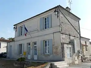 Rathaus (Mairie) von Colombiers | ||

Geographie
Colombiers liegt etwa zwölf Kilometer südsüdöstlich von Saintes. Umgeben wird Colombiers von den Nachbargemeinden La Jard im Norden und Westen, Montils im Osten sowie Saint-Léger im Süden.
Bevölkerungsentwicklung
| Jahr | 1962 | 1968 | 1975 | 1982 | 1990 | 1999 | 2006 | 2017 |
| Einwohner | 283 | 216 | 222 | 218 | 217 | 254 | 318 | 313 |
| Quellen: Cassini und INSEE | ||||||||
Sehenswürdigkeiten
- Kirche Saint-Maclou aus dem 12. Jahrhundert, seit 1908 Monument historique (siehe auch: Liste der Monuments historiques in Colombiers (Charente-Maritime))
- Kapelle Notre-Dame, 1995 bis 1997 erbaut
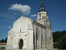
Kirche Saint-Maclou
Literatur
- Le Patrimoine des Communes de la Charente-Maritime. Flohic Editions, Band 2, Paris 2002, ISBN 2-84234-129-5, S. 986–987.
This article is issued from Wikipedia. The text is licensed under Creative Commons - Attribution - Sharealike. The authors of the article are listed here. Additional terms may apply for the media files, click on images to show image meta data.