Souligné-sous-Ballon
| Souligné-sous-Ballon | ||
|---|---|---|
.svg.png.webp)
|
| |
| Staat | Frankreich | |
| Region | Pays de la Loire | |
| Département (Nr.) | Sarthe (72) | |
| Arrondissement | Le Mans | |
| Kanton | Bonnétable | |
| Gemeindeverband | Maine Cœur de Sarthe | |
| Koordinaten | 48° 8′ N, 0° 14′ O | |
| Höhe | 51–103 m | |
| Fläche | 12,73 km² | |
| Einwohner | 1.239 (1. Januar 2019) | |
| Bevölkerungsdichte | 97 Einw./km² | |
| Postleitzahl | 72290 | |
| INSEE-Code | 72340 | |
| Website | http://souligne-sous-ballon.fr/ | |
_mairie.jpg.webp) Rathaus (Mairie) von Souligné-sous-Ballon | ||

Souligné-sous-Ballon ist eine französische Gemeinde mit 1.239 Einwohnern (Stand: 1. Januar 2019) im Département Sarthe in der Region Pays de la Loire. Sie gehört zum Arrondissement Le Mans und zum Kanton Bonnétable (bis 2015: Kanton Ballon). Die Einwohner werden Soulignéens genannt.
Geographie
Souligné-sous-Ballon liegt etwa 14 Kilometer nordnordöstlich von Le Mans. Umgeben wird Souligné-sous-Ballon von den Nachbargemeinden Ballon-Saint Mars im Norden und Nordosten, Courcebœufs im Osten, Joué-l’Abbé im Süden, La Guierche im Westen und Südwesten sowie Montbizot im Westen und Nordwesten.
Bevölkerungsentwicklung
| Jahr | 1962 | 1968 | 1975 | 1982 | 1990 | 1999 | 2006 | 2013 |
| Einwohner | 869 | 849 | 805 | 847 | 916 | 1.009 | 1.157 | 1.144 |
| Quelle: Cassini und INSEE | ||||||||
Sehenswürdigkeiten
- Kirche Saint-Martin, von 1832 bis 1834 erbaut
- Schloss La Freslonnière
- Kruzifix
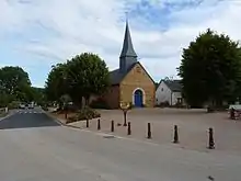
Kirche Saint-Martin
Literatur
- Le Patrimoine des Communes de la Sarthe. Flohic Editions, Band 1, Paris 2000, ISBN 2-84234-106-6, S. 127–130.
This article is issued from Wikipedia. The text is licensed under Creative Commons - Attribution - Sharealike. The authors of the article are listed here. Additional terms may apply for the media files, click on images to show image meta data.