Souillé
Souillé ist eine französische Gemeinde mit 743 Einwohnern (Stand: 1. Januar 2019) im Département Sarthe in der Region Pays de la Loire. Sie gehört zum Arrondissement Le Mans und zum Kanton Bonnétable. Die Einwohner werden Souilléens genannt.
| Souillé | ||
|---|---|---|
| ||
| Staat | Frankreich | |
| Region | Pays de la Loire | |
| Département (Nr.) | Sarthe (72) | |
| Arrondissement | Le Mans | |
| Kanton | Bonnétable | |
| Gemeindeverband | Maine Cœur de Sarthe | |
| Koordinaten | 48° 7′ N, 0° 11′ O | |
| Höhe | 49–87 m | |
| Fläche | 4,59 km² | |
| Einwohner | 743 (1. Januar 2019) | |
| Bevölkerungsdichte | 162 Einw./km² | |
| Postleitzahl | 72380 | |
| INSEE-Code | 72338 | |
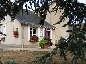 Rathaus (Mairie) von Souillé | ||

Geographie
Souillé liegt etwa zwölf Kilometer nördlich von Le Mans. Die Sarthe begrenzt die Gemeinde im Osten. Umgeben wird Souillé von den Nachbargemeinden Sainte-Jamme-sur-Sarthe im Norden, Montbizot im Norden und Nordosten, La Guierche im Osten sowie La Bazoge im Süden und Westen.
Bevölkerungsentwicklung
| Jahr | 1962 | 1968 | 1975 | 1982 | 1990 | 1999 | 2006 | 2018 |
| Einwohner | 227 | 210 | 276 | 274 | 308 | 365 | 547 | 716 |
| Quellen: Cassini und INSEE | ||||||||
Sehenswürdigkeiten
- Kirche Saint-Martin
- Kapelle Sainte-Anne
- Wassermühle
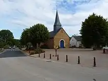
Kirche Saint-Martin
Literatur
- Le Patrimoine des Communes de la Sarthe. Flohic Editions, Band 1, Paris 2000, ISBN 2-84234-106-6, S. 125–127.
This article is issued from Wikipedia. The text is licensed under Creative Commons - Attribution - Sharealike. The authors of the article are listed here. Additional terms may apply for the media files, click on images to show image meta data.