La Chapelle-Saint-Aubin
La Chapelle-Saint-Aubin ist eine französische Gemeinde mit 2.302 Einwohnern (Stand: 1. Januar 2019) im Département Sarthe in der Region Pays de la Loire; sie gehört zum Arrondissement Le Mans und zum Kanton Le Mans-2. Die Einwohner werden Capellaubinois genannt.
| La Chapelle-Saint-Aubin | ||
|---|---|---|
| ||
| Staat | Frankreich | |
| Region | Pays de la Loire | |
| Département (Nr.) | Sarthe (72) | |
| Arrondissement | Le Mans | |
| Kanton | Le Mans-2 | |
| Gemeindeverband | Le Mans Métropole | |
| Koordinaten | 48° 2′ N, 0° 10′ O | |
| Höhe | 42–128 m | |
| Fläche | 5,98 km² | |
| Einwohner | 2.302 (1. Januar 2019) | |
| Bevölkerungsdichte | 385 Einw./km² | |
| Postleitzahl | 72650 | |
| INSEE-Code | 72065 | |
| Website | www.ville-lachapellesaintaubin.eu/ | |
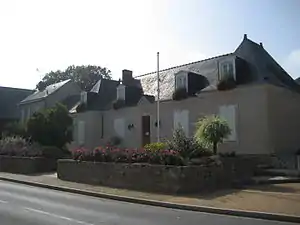 Rathaus von La Chapelle-Saint-Aubin | ||

Geographie
La Chapelle-Saint-Aubin liegt an der Sarthe, etwa vier Kilometer nordnordwestlich von Le Mans. Umgeben wird La Chapelle-Saint-Aubin von den Nachbargemeinden La Milesse im Norden und Nordwesten, Saint-Saturnin im Norden und Nordosten, Saint-Pavace im Osten, Le Mans im Süden sowie Trangé im Westen.
In der Gemeinde liegt das Autobahndreieck der Autoroute A11 mit der Autoroute A81.
Bevölkerungsentwicklung
| 1962 | 1968 | 1975 | 1982 | 1990 | 1999 | 2006 | 2018 |
|---|---|---|---|---|---|---|---|
| 615 | 678 | 921 | 1559 | 1817 | 2094 | 2165 | 2331 |
Sehenswürdigkeiten
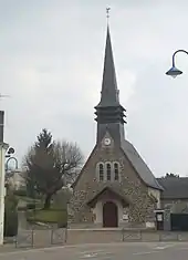
Kirche Saint-Aubin
- Kirche Saint-Aubin, neu erbaut 1916, nachdem die frühere Kirche abgebrannt war
This article is issued from Wikipedia. The text is licensed under Creative Commons - Attribution - Sharealike. The authors of the article are listed here. Additional terms may apply for the media files, click on images to show image meta data.