Saint-Aubin-de-Branne
Saint-Aubin-de-Branne ist eine französische Gemeinde mit 368 Einwohnern (Stand: 1. Januar 2019) im Département Gironde in der Region Nouvelle-Aquitaine (vor 2016 Aquitaine); sie gehört zum Arrondissement Libourne und zum Kanton Les Coteaux de Dordogne (bis 2015 Branne). Die Einwohner werden Saint-Aubinois genannt.
| Saint-Aubin-de-Branne | ||
|---|---|---|
| ||
| Staat | Frankreich | |
| Region | Nouvelle-Aquitaine | |
| Département (Nr.) | Gironde (33) | |
| Arrondissement | Libourne | |
| Kanton | Les Coteaux de Dordogne | |
| Gemeindeverband | Castillon-Pujols | |
| Koordinaten | 44° 49′ N, 0° 10′ W | |
| Höhe | 2–88 m | |
| Fläche | 5,51 km² | |
| Einwohner | 368 (1. Januar 2019) | |
| Bevölkerungsdichte | 67 Einw./km² | |
| Postleitzahl | 33420 | |
| INSEE-Code | 33375 | |
| Website | https://www.saint-aubin-de-branne.fr/ | |

Geographie
Saint-Aubin-de-Branne liegt etwa 41 Kilometer östlich von Bordeaux. An der östlichen Gemeindegrenze verläuft der Fluss Engranne. Umgeben wird Saint-Aubin-de-Branne von den Nachbargemeinden Branne und Cabara im Norden, Sainte-Terre im Nordosten, Saint-Jean-de-Blaignac im Osten, Rauzan im Südosten, Naujan-et-Postiac im Süden sowie Lugaignac im Westen.
Bevölkerungsentwicklung
| Jahr | 1962 | 1968 | 1975 | 1982 | 1990 | 1999 | 2006 | 2017 |
| Einwohner | 245 | 228 | 222 | 251 | 278 | 282 | 350 | 351 |
| Quellen: Cassini und INSEE | ||||||||
Sehenswürdigkeiten
- Kirche Notre-Dame (Monument historique)
- Schloss Le Bedat
- Schloss L'Hérisson
- Schloss Conques
- Mühlen von Lescours und L'Estrebeau
Literatur
- Le Patrimoine des Communes de la Gironde. Flohic Éditions, Band 1, Paris 2001, ISBN 2-84234-125-2, S. 412–413.
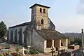 Kirche Notre-Dame
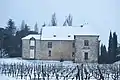 Schloss L'Hérisson
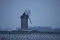 Mühle von Lescours
Weblinks
Commons: Saint-Aubin-de-Branne – Sammlung von Bildern, Videos und Audiodateien
This article is issued from Wikipedia. The text is licensed under Creative Commons - Attribution - Sharealike. The authors of the article are listed here. Additional terms may apply for the media files, click on images to show image meta data.