Doulezon
Doulezon ist eine französische Gemeinde mit 266 Einwohnern (Stand: 1. Januar 2019) im Département Gironde in der Region Nouvelle-Aquitaine (vor 2016 Aquitaine); sie gehört zum Arrondissement Libourne und zum Kanton Les Coteaux de Dordogne (bis 2015 Pujols). Die Einwohner werden Doulezonnais genannt werden.
| Doulezon | ||
|---|---|---|
| ||
| Staat | Frankreich | |
| Region | Nouvelle-Aquitaine | |
| Département (Nr.) | Gironde (33) | |
| Arrondissement | Libourne | |
| Kanton | Les Coteaux de Dordogne | |
| Gemeindeverband | Castillon-Pujols | |
| Koordinaten | 44° 48′ N, 0° 0′ W | |
| Höhe | 26–112 m | |
| Fläche | 7,53 km² | |
| Einwohner | 266 (1. Januar 2019) | |
| Bevölkerungsdichte | 35 Einw./km² | |
| Postleitzahl | 33350 | |
| INSEE-Code | 33153 | |
 Rathaus (Mairie) von Doulezon | ||

Geographie
Doulezon liegt etwa 50 Kilometer östlich von Bordeaux. Umgeben wird Doulezon von den Nachbargemeinden Sainte-Radegonde im Norden und Osten, Saint-Antoine-du-Queyret im Süden und Südosten, Ruch im Süden und Südwesten, Pujols im Westen und Nordwesten sowie Mouliets-et-Villemartin im Westen.
Bevölkerungsentwicklung
| Jahr | 1962 | 1968 | 1975 | 1982 | 1990 | 1999 | 2006 | 2017 |
| Einwohner | 314 | 327 | 225 | 183 | 212 | 230 | 246 | 265 |
| Quellen: Cassini und INSEE | ||||||||
Sehenswürdigkeiten
- Kirche Notre-Dame aus dem 11. Jahrhundert, Monument historique seit 2002
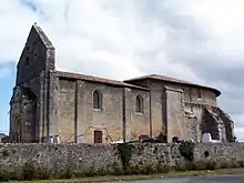
Kirche Notre-Dame
Literatur
- Le Patrimoine des Communes de la Gironde. Flohic Éditions, Band 2, Paris 2001, ISBN 2-84234-125-2, S. 1159–1161.
Weblinks
Commons: Doulezon – Sammlung von Bildern, Videos und Audiodateien
This article is issued from Wikipedia. The text is licensed under Creative Commons - Attribution - Sharealike. The authors of the article are listed here. Additional terms may apply for the media files, click on images to show image meta data.