Passo di Pontimia
Der Passo di Pontimia ist ein Gebirgspass in den Walliser Alpen. Auf der Passhöhe verläuft die Grenze zwischen Italien und der Schweiz. Auf einer Höhe von 2379 m ü. M. verbindet er die Orte Gondo (855 m) und Bognanco (980 m). Über den Pass führt ein Saumpfad und Wanderweg.
| Passo di Pontimia | |||
|---|---|---|---|
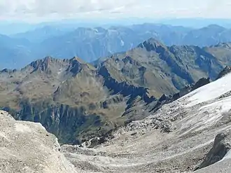 Blick vom Zwischbergenpass auf die Alpe Pontimia Blick vom Zwischbergenpass auf die Alpe Pontimia | |||
| Himmelsrichtung | Nord | Ost | |
| Passhöhe | 2379 m | ||
| Region | Kanton Wallis | Region Piemont | |
| Wasserscheide | Grosses Wasser, Diveria, Toce | Bogna, Toce | |
| Talorte | Gondo / Simplonpass | Bognanco / Valle di Bongnaco | |
| Ausbau | Saumpfad | ||
| Gebirge | Walliser Alpen | ||
| Karte (Wallis) | |||
| |||
| Koordinaten, (CH) | 46° 7′ 22″ N, 8° 6′ 54″ O (652275 / 108152) | ||
Der Pass liegt zwischen dem Pizzo Sraciugo (2713 m) im Norden und der Cima del Rosso (2624 m) im Süden.[1]
Weblinks
Einzelnachweise
Albrun | Antrona | Augstbord | Balme | Barna | Bocchetta di Val Maggia | Boeuf | Bunderchrinde | Carmenna | Carnusa | Casanna | Chaschauna | Chésery | Cheville | Chräzeren | Chrüzli | Corno | Cristallina | Cou | Diesrut | Durand | Duranna | Encel | Euschels | Ferret Grand | Ferret Petit | Foo | Fórcola | Fuorcla Surlej | Fuorcla da Patnaul | Furcletta | Futschöl | Geisspfad | Gemmi | Giümela | Gredigs Fürggli | Greina | Gries | Grünenberg | Güner Lückli | Guriner Furggu | Heidel | Heubützli | Hörnligrat | Illsee | Joch | Jorat | Chinzig | Kisten | Kleine Scheidegg | Lona | Lötschen | Lys | Maienfelder Furgga | Meidpass | Menouve | Monte Moro | Muretto | Naret | Niemet | Panixer | Pontimia | Rawil | Redorta | Riseten | Rotstein | Saas | Safierberg | Saflisch | San Giacomo | San Jorio | Sattel | Scaletta | Schlappiner Joch | Schnidejoch | Schonegg | Schwialp | Segnes | Septimer | Sertig | Soladier | Soreda | Stallerberg | Strela | Surenen | Susanfe | Tamier | Theodul | Tomül | Torrent | Trescolmen | Trütlisberg | Urdenfürggli | Valserberg | Zeblasjoch | Zwischbergen