Nantiat
Nantiat (okzitanisch: Nantiac) ist eine Gemeinde mit 1.614 Einwohnern (Stand: 1. Januar 2019) im Norden des Départements Haute-Vienne in Frankreich. Nantiat gehört zum Arrondissement Bellac und zum Kanton Bellac (bis 2015: Kanton Nantiat). Die Einwohner nennen sich Nantiauds.
| Nantiat Nantiac | ||
|---|---|---|
.svg.png.webp)
|
| |
| Staat | Frankreich | |
| Region | Nouvelle-Aquitaine | |
| Département (Nr.) | Haute-Vienne (87) | |
| Arrondissement | Bellac | |
| Kanton | Bellac | |
| Gemeindeverband | Élan Limousin Avenir Nature | |
| Koordinaten | 46° 1′ N, 1° 10′ O | |
| Höhe | 258–422 m | |
| Fläche | 26,08 km² | |
| Einwohner | 1.614 (1. Januar 2019) | |
| Bevölkerungsdichte | 62 Einw./km² | |
| Postleitzahl | 87140 | |
| INSEE-Code | 87103 | |
| Website | http://www.nantiat.fr/ | |

Geographie
Nantiat liegt etwa 21 Kilometer nordnordwestlich von Limoges. Umgeben wird Nantiat von den Nachbargemeinden Saint-Pardoux-le-Lac mit Roussac im Norden, Le Buis im Nordosten, Thouron im Osten, Saint-Jouvent im Süden und Südosten, Peyrilhac im Süden und Südwesten, Chamboret im Westen sowie Berneuil im Nordwesten.
Durch die Gemeinde führt die frühere Route nationale 711.
Bevölkerungsentwicklung
| Jahr | 1962 | 1968 | 1975 | 1982 | 1990 | 1999 | 2006 | 2013 |
|---|---|---|---|---|---|---|---|---|
| Einwohner | 1.418 | 1.432 | 1.406 | 1.441 | 1.561 | 1.623 | 1.633 | 1.570 |
| Quelle: Cassini und INSEE | ||||||||
Sehenswürdigkeiten
- Menhir La Croix Parot
- Kirche Saint-Vincent
- Schloss Les Lezes
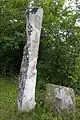 Menhir La Croix Parot
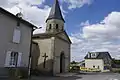 Kirche Saint-Vincent
 Schloss Les Lezes
This article is issued from Wikipedia. The text is licensed under Creative Commons - Attribution - Sharealike. The authors of the article are listed here. Additional terms may apply for the media files, click on images to show image meta data.