Milon-la-Chapelle
Milon-la-Chapelle ist eine französische Gemeinde mit 283 Einwohnern (Stand: 1. Januar 2019) im Département Yvelines in der Region Île-de-France. Sie gehört zum Arrondissement Rambouillet und zum Kanton Maurepas (bis 2015: Kanton Chevreuse). Die Einwohner werden Milonais genannt.
| Milon-la-Chapelle | ||
|---|---|---|
| ||
| Staat | Frankreich | |
| Region | Île-de-France | |
| Département (Nr.) | Yvelines (78) | |
| Arrondissement | Rambouillet | |
| Kanton | Maurepas | |
| Gemeindeverband | Haute Vallée de Chevreuse | |
| Koordinaten | 48° 44′ N, 2° 4′ O | |
| Höhe | 80–164 m | |
| Fläche | 3,09 km² | |
| Einwohner | 283 (1. Januar 2019) | |
| Bevölkerungsdichte | 92 Einw./km² | |
| Postleitzahl | 78470 | |
| INSEE-Code | 78406 | |
| Website | https://www.milon-la-chapelle.fr/ | |
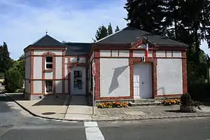 Rathaus (Mairie) von Milon-la-Chapelle | ||

Geographie
Die Gemeinde liegt im Regionalen Naturpark Haute Vallée de Chevreuse, etwa 29 Kilometer westsüdwestlich von Paris und wird umgeben von den Nachbargemeinden Magny-les-Hameaux im Norden und Osten, Saint-Rémy-lès-Chevreuse im Südosten, Chevreuse im Süden sowie Saint-Lambert im Westen.
Bevölkerungsentwicklung
| Jahr | 1962 | 1968 | 1975 | 1982 | 1990 | 1999 | 2006 | 2013 |
| Einwohner | 282 | 233 | 288 | 340 | 335 | 339 | 321 | 272 |
| Quelle: Cassini und INSEE | ||||||||
Sehenswürdigkeiten
Siehe auch: Liste der Monuments historiques in Milon-la-Chapelle
- Kirche Notre-Dame-de-l'Assomption aus dem 12. Jahrhundert
- Schloss Milon von 1764
- Schloss Vert-Cœur aus dem 19. Jahrhundert
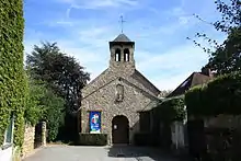
Kirche Notre-Dame-de-l'Assomption
Literatur
- Le Patrimoine des Communes des Yvelines. Band 1, Flohic Editions, Paris 2000, ISBN 2-84234-070-1, S. 189–191.
This article is issued from Wikipedia. The text is licensed under Creative Commons - Attribution - Sharealike. The authors of the article are listed here. Additional terms may apply for the media files, click on images to show image meta data.