Marsac (Charente)
Marsac ist eine französische Gemeinde mit 817 Einwohnern (Stand: 1. Januar 2019) im Département Charente in der Region Nouvelle-Aquitaine; sie gehört zum Arrondissement Angoulême und zum Kanton Val de Nouère. Die Einwohner werden Marsacois genannt.
| Marsac | ||
|---|---|---|

|
| |
| Staat | Frankreich | |
| Region | Nouvelle-Aquitaine | |
| Département (Nr.) | Charente (16) | |
| Arrondissement | Angoulême | |
| Kanton | Val de Nouère | |
| Gemeindeverband | Grand Angoulême | |
| Koordinaten | 45° 45′ N, 0° 5′ O | |
| Höhe | 35–143 m | |
| Fläche | 13,36 km² | |
| Einwohner | 817 (1. Januar 2019) | |
| Bevölkerungsdichte | 61 Einw./km² | |
| Postleitzahl | 16570 | |
| INSEE-Code | 16210 | |
 Rathaus (Mairie) von Marsac | ||

Geographie
Marsac liegt etwa elf Kilometer nordnordwestlich von Angoulême an der Charente. Umgeben wird Marsac von den Nachbargemeinden Saint-Genis-d’Hiersac im Norden und Westen, Montignac-Charente im Norden und Nordosten, Vars im Osten, Vindelle im Süden und Südosten sowie Asnières-sur-Nouère im Südwesten.
Durch die Gemeinde verläuft die frühere Route nationale 139 (D939).
Bevölkerungsentwicklung
| 1962 | 1968 | 1975 | 1982 | 1990 | 1999 | 2006 | 2018 |
|---|---|---|---|---|---|---|---|
| 515 | 505 | 484 | 600 | 708 | 720 | 769 | 822 |
| Quellen: Cassini und INSEE | |||||||
Sehenswürdigkeiten
- Kirche Saint-Protais-et-Saint-Gervais aus dem 12. Jahrhundert, seit 1941 Monument historique
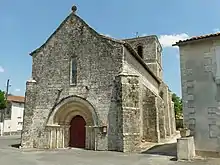
Kirche Saint-Protais-et-Saint-Gervais
This article is issued from Wikipedia. The text is licensed under Creative Commons - Attribution - Sharealike. The authors of the article are listed here. Additional terms may apply for the media files, click on images to show image meta data.