Liste der Orte in der Gemeinde Manatuto
Die Liste der Orte in der Gemeinde Manatuto gibt an, welche Ortschaften in jedem Suco der osttimoresischen Gemeinde Manatuto liegen und welche geographische Koordinaten und Meereshöhe sie haben.
Landkarten
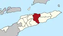
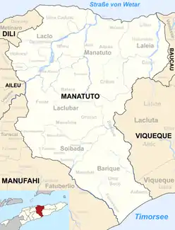 Die Gemeinde Manatuto
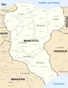 Die Gemeinde Manatuto in den Grenzen bis 2015
Liste
Das Verwaltungsamt Barique
| Verwaltungsamt Barique | |||||||
| |||||||
| Suco Aubeon | |||||||
| Orte | Position | Höhe | Orte | Position | Höhe | ||
| Buburlaran | 8° 58′ 55″ S, 126° 3′ 40″ O | 92 m | Waicadi | 8° 59′ 28″ S, 126° 3′ 37″ O | 73 m | ||
| Wecadi | 8° 58′ 25″ S, 126° 6′ 4″ O[1] | ? | Wemaubodak | 8° 58′ 52″ S, 126° 3′ 7″ O | 100 m | ||
| Suco Barique | |||||||
| Orte | Position | Höhe | Orte | Position | Höhe | ||
| Barique | 8° 50′ 0″ S, 126° 4′ 0″ O | 301 m | Caunua | 8° 50′ 49″ S, 126° 3′ 54″ O | 303 m | ||
| Weubani | 8° 50′ 52″ S, 126° 3′ 50″ O | 303 m | |||||
| Suco Fatuwaque | |||||||
| Orte | Position | Höhe | Orte | Position | Höhe | ||
| Camedar | 8° 58′ 18″ S, 126° 3′ 32″ O | 113 m | Ranac | 8° 58′ 22″ S, 126° 3′ 40″ O | 113 m | ||
| Wemau Badak | 8° 57′ 4″ S, 126° 5′ 48″ O[1] | ? | |||||
| Suco Manehat | |||||||
| Orte | Position | Höhe | Orte | Position | Höhe | ||
| Dambua Hun | 8° 54′ 50″ S, 125° 58′ 5″ O | 653 m | Fatobalon | 8° 54′ 50″ S, 125° 58′ 18″ O | 642 m | ||
| Isadan | 8° 56′ 17″ S, 125° 57′ 49″ O[1] | ? | Manehat | 8° 54′ 47″ S, 125° 58′ 3″ O | 653 m | ||
| Nu-Ahuc | 8° 54′ 54″ S, 125° 58′ 16″ O | 642 m | |||||
| Suco Uma Boco | |||||||
| Orte | Position | Höhe | Orte | Position | Höhe | ||
| Camedar | 8° 59′ 8″ S, 126° 1′ 36″ O[1] | ? | Fehuc Rin | 8° 58′ 37″ S, 126° 2′ 42″ O | 130 m | ||
| Uma Boco | 8° 58′ 33″ S, 126° 2′ 48″ O | 122 m | |||||
Das Verwaltungsamt Laclo
Das Verwaltungsamt Laclubar
| Verwaltungsamt Laclubar | |||||||
| |||||||
| Suco Batara | |||||||
| Orte | Position | Höhe | Orte | Position | Höhe | ||
| Are Ain | 8° 44′ 6″ S, 125° 55′ 0″ O | 980 m | Balulin | 8° 44′ 43″ S, 125° 54′ 16″ O | 1074 m | ||
| Fatuha | 8° 44′ 26″ S, 125° 54′ 30″ O | 1074 m | Lihutula | 8° 44′ 23″ S, 125° 55′ 7″ O | 1012 m | ||
| Werulun | 8° 44′ 23″ S, 125° 54′ 40″ O | 1074 m | |||||
| Suco Fatumaquerec | |||||||
| Orte | Position | Höhe | Orte | Position | Höhe | ||
| Darfu | 8° 43′ 48″ S, 125° 51′ 50″ O | 1333 m | Laramera | 8° 43′ 24″ S, 125° 58′ 39″ O | 1009 m | ||
| Lisuata | 8° 43′ 21″ S, 125° 58′ 45″ O | 979 m | Manukasak | 8° 43′ 29″ S, 125° 58′ 27″ O | 1009 m | ||
| Sasahi | 8° 43′ 6″ S, 125° 58′ 42″ O | 841 m | |||||
| Suco Funar | |||||||
| Orte | Position | Höhe | Orte | Position | Höhe | ||
| Funar | 8° 45′ 2″ S, 125° 52′ 7″ O[1] | ? | Sassahi | 8° 46′ 20″ S, 125° 53′ 5″ O[1] | ? | ||
| Suco Manelima | |||||||
| Orte | Position | Höhe | Orte | Position | Höhe | ||
| Aman Un | 8° 48′ 20″ S, 125° 55′ 13″ O | 940 m | Calohan | 8° 45′ 24″ S, 125° 55′ 38″ O | 1124 m | ||
| Hatomanuc | 8° 47′ 30″ S, 125° 55′ 52″ O | 950 m | Laceno | 8° 48′ 32″ S, 125° 55′ 10″ O | 940 m | ||
| Lafulau | 8° 48′ 10″ S, 125° 55′ 19″ O | 1004 m | Mane-Atun | 8° 46′ 44″ S, 125° 55′ 31″ O | 1199 m | ||
| Manelima | 8° 46′ 1″ S, 125° 54′ 0″ O | 1246 m | |||||
| Suco Orlalan | |||||||
| Orte | Position | Höhe | Orte | Position | Höhe | ||
| Bamatac | 8° 45′ 7″ S, 125° 54′ 6″ O | 1192 m | Hatolalan | 8° 44′ 56″ S, 125° 56′ 28″ O | 1068 m | ||
| Hatomalos | 8° 44′ 47″ S, 125° 56′ 7″ O | 1037 m | Laclubar | 8° 44′ 47″ S, 125° 54′ 40″ O | 1120 m | ||
| Lawado | 8° 45′ 2″ S, 125° 54′ 17″ O | 1120 m | Le'i | 8° 45′ 21″ S, 125° 57′ 40″ O | 1204 m | ||
| Nauleau | 8° 45′ 15″ S, 125° 57′ 25″ O | 1204 m | Orlalan | 8° 45′ 6″ S, 125° 55′ 0″ O | 1077 m | ||
| Pualaca | 8° 47′ 26″ S, 125° 58′ 10″ O[1] | ? | Torilalan | 8° 45′ 3″ S, 125° 54′ 34″ O | 1120 m | ||
| Suco Sananain | |||||||
| Orte | Position | Höhe | Orte | Position | Höhe | ||
| Fatu-Uc | 8° 38′ 23″ S, 125° 58′ 34″ O | 316 m | Ruhetun | 8° 38′ 32″ S, 125° 58′ 34″ O | 316 m | ||
| Tanusa | 8° 38′ 35″ S, 125° 58′ 36″ O | 316 m | Waidarec | 8° 38′ 33″ S, 125° 58′ 38″ O | 316 m | ||
Das Verwaltungsamt Laleia
| Verwaltungsamt Laleia | |||||||
| |||||||
| Suco Cairui | |||||||
| Orte | Position | Höhe | Orte | Position | Höhe | ||
| Bia-Ba'e | 8° 36′ 33″ S, 126° 8′ 37″ O | 184 m | Corohoco | 8° 36′ 21″ S, 126° 8′ 39″ O | 184 m | ||
| Rai-Bu | 8° 36′ 18″ S, 126° 8′ 41″ O | 184 m | Rai-Mea | 8° 36′ 26″ S, 126° 8′ 38″ O | 184 m | ||
| Samalai | 8° 34′ 37″ S, 126° 9′ 36″ O | 125 m | Uai-Nunu | 8° 36′ 26″ S, 126° 8′ 45″ O | 184 m | ||
| Uatu-Sili | 8° 36′ 22″ S, 126° 8′ 47″ O | 205 m | |||||
| Suco Haturalan | |||||||
| Orte | Position | Höhe | Orte | Position | Höhe | ||
| Hatu Carau | ? | Ralan | 8° 32′ 20″ S, 126° 9′ 53″ O | 121 m | |||
| Uma-Iuc | 8° 32′ 28″ S, 126° 9′ 44″ O | 80 m | Ueboro | 8° 32′ 26″ S, 126° 9′ 55″ O | 122 m | ||
| Suco Lifau | |||||||
| Orte | Position | Höhe | Orte | Position | Höhe | ||
| Laleia | 8° 32′ 16″ S, 126° 10′ 0″ O[1] | 156 m | Lenao | 8° 32′ 16″ S, 126° 9′ 44″ O[1] | ? | ||
| Lifau | 8° 32′ 15″ S, 126° 9′ 50″ O[1] | 121 m | Uma-Rentau | 8° 31′ 55″ S, 126° 9′ 43″ O[1] | ? | ||
Das Verwaltungsamt Manatuto
| Verwaltungsamt Manatuto | |||||||
| |||||||
| Suco Ailili | |||||||
| Orte | Position | Höhe | Orte | Position | Höhe | ||
| Belbato (West) | 8° 32′ 46″ S, 126° 0′ 4″ O[1] | ? | Nunuli | 8° 31′ 51″ S, 125° 59′ 19″ O | 72 m | ||
| Nai | 8° 31′ 56″ S, 125° 59′ 56″ O[1] | ? | Rembor | 8° 32′ 40″ S, 125° 57′ 55″ O | 96 m | ||
| Suco Aiteas | |||||||
| Orte | Position | Höhe | Orte | Position | Höhe | ||
| Belbato | 8° 31′ 39″ S, 126° 0′ 18″ O[1] | ? | Carlilu | 8° 32′ 2″ S, 126° 0′ 24″ O | 109 m | ||
| Lahuoae | 8° 31′ 16″ S, 126° 0′ 25″ O | 63 m | |||||
| Suco Cribas | |||||||
| Orte | Position | Höhe | Orte | Position | Höhe | ||
| Athoc | 8° 40′ 31″ S, 125° 59′ 33″ O | 509 m | Tuquete | 8° 40′ 34″ S, 125° 59′ 26″ O | 509 m | ||
| Suco Iliheu | |||||||
| Orte | Position | Höhe | Orte | Position | Höhe | ||
| Ili-Huli | 8° 32′ 20″ S, 125° 56′ 46″ O | 113 m | I-Un | 8° 32′ 36″ S, 125° 56′ 35″ O | 149 m | ||
| Suco Ma'abat | |||||||
| Orte | Position | Höhe | Orte | Position | Höhe | ||
| Aitehen | 8° 30′ 46″ S, 126° 1′ 50″ O | 21 m | Berato | 8° 30′ 52″ S, 126° 1′ 12″ O | 29 m | ||
| Dadean Huhun | 8° 31′ 9″ S, 126° 2′ 35″ O | 2 m | Ma'abat | 8° 30′ 45″ S, 126° 1′ 14″ O | 29 m | ||
| Manatuto | 8° 30′ 41″ S, 126° 0′ 47″ O | 0 m | Soraha | 8° 31′ 35″ S, 126° 1′ 29″ O | 74 m | ||
| Suco Sau | |||||||
| Orte | Position | Höhe | Orte | Position | Höhe | ||
| Ailili | 8° 30′ 43″ S, 126° 0′ 42″ O | 0 m | Aiteas | 8° 30′ 38″ S, 126° 0′ 57″ O | 0 m | ||
| Iun | 8° 30′ 50″ S, 126° 0′ 57″ O | 29 m | Malarahu | 8° 31′ 18″ S, 125° 59′ 52″ O | 52 m | ||
| Manatuto | 8° 30′ 41″ S, 126° 0′ 47″ O | 0 m | Obrato | 8° 30′ 15″ S, 125° 59′ 51″ O | 0 m | ||
| Obrato 1 | 8° 29′ 50″ S, 125° 59′ 40″ O | 0 m | Sau | 8° 30′ 36″ S, 126° 0′ 40″ O | 0 m | ||
Das Verwaltungsamt Soibada
| Verwaltungsamt Soibada | |||||||
| |||||||
| Suco Fatumaquerec | |||||||
| Orte | Position | Höhe | Orte | Position | Höhe | ||
| Hisuala | 8° 51′ 39″ S, 125° 56′ 5″ O | 613 m | Sasahi | 8° 51′ 45″ S, 125° 56′ 10″ O | 565 m | ||
| Uma Querec | 8° 51′ 41″ S, 125° 56′ 25″ O | 569 m | |||||
| Suco Leo-Hat | |||||||
| Orte | Position | Höhe | Orte | Position | Höhe | ||
| Leo-Hat | 8° 52′ 3″ S, 125° 56′ 36″ O | 535 m | Malushum | 8° 51′ 57″ S, 125° 56′ 43″ O | 535 m | ||
| Malus Hun | 8° 49′ 47″ S, 125° 59′ 16″ O[1] | ? | |||||
| Suco Manlala | |||||||
| Orte | Position | Höhe | Orte | Position | Höhe | ||
| Dauloroc | 8° 51′ 41″ S, 125° 56′ 42″ O | 569 m | Lehutula | 8° 51′ 27″ S, 125° 56′ 33″ O | 569 m | ||
| Manlala | 8° 51′ 33″ S, 125° 56′ 47″ O | 543 m | Soibada | 8° 51′ 36″ S, 125° 56′ 33″ O | 638 m | ||
| Suco Maun-Fahe | |||||||
| Orte | Position | Höhe | Orte | Position | Höhe | ||
| Maun-Fahe | 8° 49′ 52″ S, 125° 55′ 18″ O | 706 m | Teras | 8° 49′ 41″ S, 125° 55′ 14″ O | 787 m | ||
| Suco Samoro | |||||||
| Keine größeren Orte vorhanden | |||||||
Belege
Die Schreibweise der Ortsnamen folgt, sofern vorhanden, den Angaben zu den administrativen Einteilungen in:
- Jornal da República: Diploma Ministerial n.° 16/2017, mit Korrekturen vom 9. Mai 2017
Die Liste der Ortschaften wird mit folgenden Karten erstellt:
- Timor-Leste GIS-Portal (Memento vom 30. Juni 2007 im Internet Archive)
- UNMIT Karten der Distrikte 2008
Bei unterschiedlicher Schreibweise der Ortsnamen, wird den Angaben des GIS-Portals gefolgt. Die anderen Schreibweisen für einzelne Orte finden sich in den Artikel zu den einzelnen Sucos des Landes.
Die Meereshöhen und Koordinaten wurden entnommen von:
Bei Global Gazetteer aufgeführte Orte, die nicht durch eine Karte bestätigt sind, werden nicht mit in die Liste aufgenommen.
Koordinaten, die nicht bei Global Gazetteer aufgeführt sind, werden mit Hilfe von Google Maps ermittelt.
Einzelnachweise
Die administrativen Grenzen innerhalb Osttimors haben sich 2015 geändert. Dieser Artikel muss daher geprüft und gegebenenfalls aktualisiert werden. Siehe Neue administrative Grenzen.