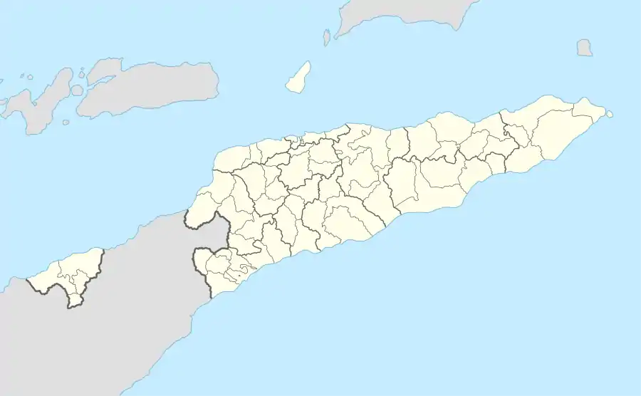
Liste der Orte in der Gemeinde Dili
Die Liste der Orte in der Gemeinde Dili gibt an, welche Ortschaften in jedem Suco der osttimoresischen Gemeinde Dili liegen und welche geographische Koordinaten und Meereshöhe sie haben. Als Orte sind hier auch die Ortsteile der Stadt Dili aufgeführt, da verwaltungstechnisch in Osttimor dabei nicht von eigenständigen Siedlungen unterschieden wird. 2022 wurde die Insel Atauro als eigenständige Gemeinde abgetrennt.
Die Änderungen von 2015 und 2017 wurden noch nicht in dieser Liste berücksichtigt.
Landkarten
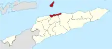
 Die Gemeinde Dili
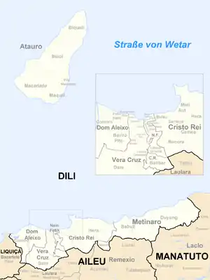
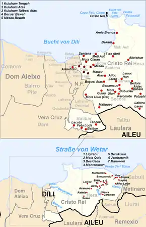 Das Verwaltungsamt Cristo Rei
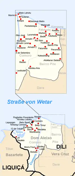 Das Verwaltungsamt Dom Aleixo
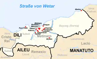 Das Verwaltungsamt Metinaro
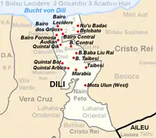 Das Verwaltungsamt Nain Feto
 Das Verwaltungsamt Vera Cruz
Liste
Das Verwaltungsamt Cristo Rei
Das Verwaltungsamt Dom Aleixo
| Verwaltungsamt Dom Aleixo | |||||||
| |||||||
| Suco Bairro Pite | |||||||
| Orte | Position | Höhe | Orte | Position | Höhe | ||
| Ailoklaran | 8° 33′ 53″ S, 125° 33′ 36″ O | 111 m | Ailoklaran do Sul | 8° 34′ 9″ S, 125° 33′ 53″ O | 114 m | ||
| Bairro Pite | 8° 33′ 33″ S, 125° 33′ 35″ O | 18 m | Fatumeta | 8° 33′ 43″ S, 125° 33′ 11″ O | 50 m | ||
| Hudilaran | 8° 33′ 28″ S, 125° 33′ 21″ O | 18 m | Kakaulidung | 8° 33′ 57″ S, 125° 33′ 17″ O | 111 m | ||
| Manleu-Ana | 8° 34′ 33″ S, 125° 32′ 39″ O | 179 m | Perumnas | 8° 33′ 45″ S, 125° 33′ 50″ O | 114 m | ||
| Suco Comoro | |||||||
| Orte | Position | Höhe | Orte | Position | Höhe | ||
| 12 de Outubro | 8° 33′ 29″ S, 125° 30′ 44″ O[1] | ? | 4 de Setembro | 8° 33′ 56″ S, 125° 32′ 6″ O[1] | ? | ||
| Aimutin 1 | 8° 33′ 19″ S, 125° 32′ 48″ O | 50 m | Aimutin 2 | 8° 33′ 43″ S, 125° 32′ 50″ O | 50 m | ||
| Aimutin Laran | 8° 33′ 38″ S, 125° 32′ 37″ O | 64 m | Badiac | 8° 34′ 17″ S, 125° 32′ 17″ O[1] | ? | ||
| Bebonuk Metin | 8° 32′ 40″ S, 125° 32′ 37″ O | 0 m | Beduku | 8° 35′ 10″ S, 125° 31′ 47″ O | 124 m | ||
| Beto Barat | 8° 33′ 3″ S, 125° 31′ 25″ O | 0 m | Beto Timur | 8° 32′ 57″ S, 125° 31′ 59″ O | 0 m | ||
| Comoro | 8° 32′ 48″ S, 125° 31′ 29″ O | 8 m | Haslaran | 8° 33′ 44″ S, 125° 32′ 16″ O | 64 m | ||
| Kampung Baru | 8° 33′ 22″ S, 125° 31′ 30″ O | 0 m | Kelapa | 8° 32′ 32″ S, 125° 32′ 16″ O[1] | ? | ||
| Lapangan Terbang Comoro | 8° 33′ 7″ S, 125° 31′ 4″ O[1] | ? | Lesibutak | 8° 34′ 43″ S, 125° 32′ 5″ O | 79 m | ||
| Lih Baulelo | 8° 33′ 56″ S, 125° 30′ 12″ O[1] | ? | Lurumata | 8° 33′ 10″ S, 125° 32′ 53″ O | 0 m | ||
| Manleuana | 8° 33′ 28″ S, 125° 31′ 43″ O | 0 m | Manleu Lidun | 8° 34′ 55″ S, 125° 31′ 58″ O[1] | ? | ||
| Marinir | 8° 32′ 28″ S, 125° 31′ 58″ O | 0 m | Mate Lahotu | 8° 32′ 21″ S, 125° 32′ 11″ O[1] | ? | ||
| Merdeka | 8° 33′ 17″ S, 125° 31′ 54″ O | 10 m | Moris Foun | 8° 34′ 58″ S, 125° 31′ 42″ O[1] | ? | ||
| Pantai Kelapa (Praia dos Coqueiros) | 8° 32′ 58″ S, 125° 32′ 27″ O | 4 m | Paularan | 8° 32′ 27″ S, 125° 32′ 13″ O | 0 m | ||
| Pomento | 8° 33′ 26″ S, 125° 32′ 17″ O | 64 m | Rai Nain | 8° 33′ 21″ S, 125° 32′ 54″ O[1] | ? | ||
| São José | 8° 33′ 18″ S, 125° 32′ 35″ O[1] | ? | São Miguel | 8° 33′ S, 125° 33′ O | ? | ||
| Suco Fatuhada | |||||||
| Orte | Position | Höhe | Orte | Position | Höhe | ||
| Fatuhada | 8° 33′ 8″ S, 125° 33′ 26″ O | 0 m | Markoni | 8° 32′ 59″ S, 125° 33′ 6″ O | 0 m | ||
| Mataruak | 8° 32′ 49″ S, 125° 33′ 6″ O | 0 m | |||||
| Suco Kampung Alor | |||||||
| Orte | Position | Höhe | Orte | Position | Höhe | ||
| Karketu | 8° 32′ 56″ S, 125° 33′ 40″ O | 0 m | Moro | 8° 33′ 8″ S, 125° 33′ 41″ O | 0 m | ||
Das Verwaltungsamt Metinaro
| Verwaltungsamt Metinaro | |||||||
| |||||||
| Suco Mantelolão | |||||||
| Orte | Position | Höhe | Orte | Position | Höhe | ||
| Besahe | 8° 32′ 38″ S, 125° 45′ 54″ O[1] | ? | Lebutun | 8° 31′ 59″ S, 125° 44′ 48″ O | 168 m | ||
| Suco Sabuli | |||||||
| Orte | Position | Höhe | Orte | Position | Höhe | ||
| Ayatan | 8° 32′ 10″ S, 125° 44′ 3″ O | 104 m | Wenunuc | 8° 31′ 48″ S, 125° 44′ 37″ O | 135 m | ||
| Kabura | 8° 31′ 54″ S, 125° 44′ 19″ O | 135 m | Manuleu | 8° 31′ 52″ S, 125° 44′ 39″ O | 135 m | ||
| Metinaro | 8° 31′ 50″ S, 125° 44′ 41″ O | 135 m | Sabuli | 8° 31′ 46″ S, 125° 44′ 10″ O | 104 m | ||
| Sukaerlaran | 8° 31′ 57″ S, 125° 44′ 22″ O | 135 m | |||||
| Suco Wenunuc | |||||||
| Orte | Position | Höhe | Orte | Position | Höhe | ||
| Duyung | 8° 31′ 43″ S, 125° 45′ 12″ O | 61 m | Manleu | 8° 29′ 18″ S, 125° 50′ 0″ O | 171 m | ||
| Nelayan | 8° 31′ 23″ S, 125° 45′ 5″ O | 61 m | Priramatan | 8° 31′ 50″ S, 125° 45′ 4″ O | 168 m | ||
Das Verwaltungsamt Nain Feto
| Verwaltungsamt Nain Feto | ||||||||
| ||||||||
| Suco Acadiru Hun | ||||||||
| Orte | Position | Höhe | Orte | Position | Höhe | |||
| Ailelehun | 8° 33′ 23″ S, 125° 35′ 6″ O | 38 m | Belebato | 8° 33′ 15″ S, 125° 35′ 20″ O | 84 m | |||
| Culuhun de Baixo | 8° 33′ 21″ S, 125° 35′ 21″ O | 84 m | Nu'u Badac | 8° 33′ 6″ S, 125° 35′ 20″ O | 43 m | |||
| Suco Bemori | ||||||||
| Orte | Position | Höhe | Orte | Position | Höhe | |||
| Bemori Baba Liu Rai | 8° 33′ 34″ S, 125° 35′ 22″ O | 84 m | Bemori Central | 8° 33′ 27″ S, 125° 35′ 20″ O | 38 m | |||
| Suco Bidau Lecidere | ||||||||
| Orte | Position | Höhe | Orte | Position | Höhe | |||
| Bairo Lecidere | 8° 33′ 1″ S, 125° 35′ 19″ O[1] | 0 m | ||||||
| Suco Gricenfor | ||||||||
| Orte | Position | Höhe | Orte | Position | Höhe | |||
| Bairo Central | 8° 33′ 17″ S, 125° 35′ 1″ O[1] | ? | Bairo dos Grilos | 8° 33′ 11″ S, 125° 34′ 59″ O[1] | ? | |||
| Bairo Formosa | 8° 33′ 18″ S, 125° 34′ 50″ O[1] | ? | ||||||
| Suco Lahane Oriental | ||||||||
| Orte | Position | Höhe | Orte | Position | Höhe | |||
| Marabia | 8° 34′ 7″ S, 125° 35′ 19″ O | 155 m | Mota Ulun (Ost) | 8° 34′ 36″ S, 125° 35′ 38″ O | 261 m | |||
| Mota Ulun (West) | 8° 34′ 25″ S, 125° 35′ 29″ O | 261 m | Quintal Arbiro | 8° 34′ 3″ S, 125° 35′ 7″ O | 128 m | |||
| Taibesi | 8° 34′ 4″ S, 125° 35′ 31″ O | 155 m | ||||||
| Suco Santa Cruz | ||||||||
| Orte | Position | Höhe | Orte | Position | Höhe | |||
| Ailele Hun | 8° 33′ 23″ S, 125° 35′ 7″ O | Audian | 8° 33′ 25″ S, 125° 34′ 54″ O | 38 m | ||||
| Bemori Babaliurai | 8° 33′ 36″ S, 125° 35′ 15″ O | Bemori Sentral | 8° 33′ 31″ S, 125° 35′ 6″ O | |||||
| Bemori Taibesi | 8° 33′ 42″ S, 125° 35′ 13″ O | Quintal Bot | 8° 33′ 51″ S, 125° 34′ 57″ O | 128 m | ||||
| Quintal Qik | 8° 33′ 36″ S, 125° 34′ 58″ O | 38 m | ||||||
Das Verwaltungsamt Vera Cruz
| Verwaltungsamt Vera Cruz | |||||||
| |||||||
| Suco Caicoli | |||||||
| Orte | Position | Höhe | Orte | Position | Höhe | ||
| Borohun | 8° 33′ 37″ S, 125° 34′ 40″ O | 11 m | Caicoli | 8° 33′ 33″ S, 125° 34′ 23″ O | 11 m | ||
| Rumbia | 8° 33′ 46″ S, 125° 34′ 46″ O | 128 m | Tahu Laran | 8° 33′ 52″ S, 125° 34′ 26″ O | |||
| Suco Colmera | |||||||
| Orte | Position | Höhe | Orte | Position | Höhe | ||
| Colmera | 8° 33′ 23″ S, 125° 34′ 27″ O[1] | 11 m | Soslodade | 8° 33′ 17″ S, 125° 34′ 23″ O[1] | 11 m | ||
| Suco Dare | |||||||
| Orte | Position | Höhe | Orte | Position | Höhe | ||
| Casnafar | 8° 36′ 18″ S, 125° 31′ 45″ O | 101 m | Bematua | 8° 36′ 13″ S, 125° 33′ 42″ O | 587 m | ||
| Dare | 8° 35′ 44″ S, 125° 34′ 9″ O | 495 m | Fatu Naba | 8° 35′ 35″ S, 125° 34′ 48″ O | 645 m | ||
| Laulara Lama | 8° 36′ 4″ S, 125° 33′ 9″ O | 558 m | Leilaus | 8° 36′ 9″ S, 125° 32′ 56″ O | ?[1] | ||
| Nahaec | 8° 35′ 31″ S, 125° 34′ 57″ O | 545 m | |||||
| Suco Lahane Ocidental | |||||||
| Orte | Position | Höhe | Orte | Position | Höhe | ||
| Aihanexun | 8° 35′ 2″ S, 125° 34′ 58″ O | 376 m | Correio | 8° 34′ 43″ S, 125° 34′ 53″ O | 248 m | ||
| Suco Mascarenhas | |||||||
| Orte | Position | Höhe | Orte | Position | Höhe | ||
| Balide | 8° 33′ 54″ S, 125° 34′ 24″ O | 114 m | Bispo Medeiros | 8° 33′ 52″ S, 125° 34′ 42″ O | 114 m | ||
| Mascarenhas | 8° 34′ 2″ S, 125° 34′ 43″ O | 114 m | |||||
| Suco Motael | |||||||
| Orte | Position | Höhe | Orte | Position | Höhe | ||
| Aitarak | 8° 32′ 56″ S, 125° 33′ 57″ O | 0 m | Bairo Alto | 8° 33′ 18″ S, 125° 34′ 7″ O | 8 m | ||
| Bebora | 8° 33′ 12″ S, 125° 33′ 56″ O | 0 m | Farol | 8° 33′ 12″ S, 125° 34′ 7″ O | 0 m | ||
| Palapaso | 8° 32′ 59″ S, 125° 34′ 9″ O | 0 m | |||||
| Suco Vila Verde | |||||||
| Orte | Position | Höhe | Orte | Position | Höhe | ||
| Banderahun | 8° 33′ 47″ S, 125° 34′ 1″ O | 114 m | Lafandaria | 8° 33′ 39″ S, 125° 34′ 10″ O | 8 m | ||
| Mata Doro | 8° 33′ 32″ S, 125° 34′ 8″ O | 8 m | Manumeta Rahun | 8° 34′ 1″ S, 125° 34′ 4″ O | 114 m | ||
| Tuanalaran | 8° 33′ 50″ S, 125° 34′ 9″ O | 114 m | Vila Verde | 8° 33′ 30″ S, 125° 34′ 3″ O | 8 m | ||
| Virgolosa | 8° 33′ 45″ S, 125° 34′ 9″ O | 114 m | |||||
Belege
Die Schreibweise der Ortsnamen folgt, sofern vorhanden, den Angaben zu den administrativen Einteilungen in:
- Jornal da Républica mit dem Diploma Ministerial n.° 199/09 (Memento vom 3. Februar 2010 im Internet Archive) (Portugiesisch; PDF; 323 kB)
Die Liste der Ortschaften wird mit folgenden Karten erstellt:
- Timor-Leste GIS-Portal (Memento vom 30. Juni 2007 im Internet Archive)
- UNMIT Karten der Distrikte 2008
Bei unterschiedlicher Schreibweise der Ortsnamen, wird den Angaben des GIS-Portals gefolgt. Die anderen Schreibweisen für einzelne Orte finden sich in den Artikel zu den einzelnen Sucos des Landes.
Die Meereshöhen und Koordinaten wurden entnommen von:
Bei Global Gazetteer aufgeführte Orte, die nicht durch eine Karte bestätigt sind, werden nicht mit in die Liste aufgenommen.
Koordinaten, die nicht bei Global Gazetteer aufgeführt sind, werden mit Hilfe von Google Maps ermittelt.
- Google Maps
Die administrativen Grenzen innerhalb Osttimors haben sich 2015 geändert. Dieser Artikel muss daher geprüft und gegebenenfalls aktualisiert werden. Siehe Neue administrative Grenzen.