Liste der Meerengen in Kanada
Die Liste der Meerengen in Kanada ist eine unvollständige Auflistung kanadischer Meerengen (bzw. Meeresstraßen), geordnet nach den Provinzen und Territorien.
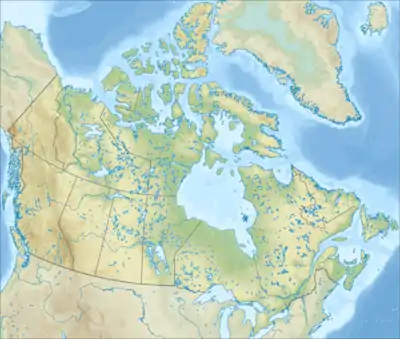
Karte von Kanada
 Alberta
keine Meerengen
 British Columbia
 Manitoba
keine Meerengen
 Neufundland und Labrador
| Name | Länge | verbindet Gewässer | mit Gewässer | trennt Landmasse | von Landmasse | Koordinaten |
|---|---|---|---|---|---|---|
| Belle-Isle-Straße | 125 km | Sankt-Lorenz-Golf | Atlantischer Ozean | Neufundland | Labrador-Halbinsel | 51° 40′ N, 056° 15′ W |
| Cabotstraße | 110 km | Sankt-Lorenz-Golf | Atlantischer Ozean | Neufundland | Kap-Breton-Insel | 47° 14′ N, 059° 43′ W |
 New Brunswick
| Name | Länge | verbindet Gewässer | mit Gewässer | trennt Landmasse | von Landmasse | Koordinaten |
|---|---|---|---|---|---|---|
| Northumber- landstraße |
13 km | Sankt-Lorenz-Golf | kanadisches Festland | Prince Edward Island | 46° 00′ N, 063° 30′ W |
 Nordwest-Territorien
| Name | Länge | verbindet Gewässer | mit Gewässer | trennt Landmasse | von Landmasse | Koordinaten |
|---|---|---|---|---|---|---|
| McClure Strait | 300 km | Viscount-Melville-Sund | Beaufortsee | Banksinsel | Melville Island, Prince Patrick Island, Eglinton Island | 74° 50′ N, 118° 05′ W |
| Parry Channel | 1.000 km | Baffin Bay | Beaufortsee | Nördliche Inseln des kanadisch-arktischen Archipels | Südliche Inseln des kanadisch-arktischen Archipels | 74° 00′ N, 093° 00′ W |
| Prince of Wales Strait | 300 km | Amundsen-Golf | Viscount-Melville-Sund | Victoria Island | Banksinsel | 72° 40′ N, 118° 30′ W |
| Wilkins Strait | 120 km | Arktischer Ozean | Arktischer Ozean | Borden Island | Mackenzie King Island | 78° 10′ N, 112° 00′ W |
 Nova Scotia
| Name | Länge | verbindet Gewässer | mit Gewässer | trennt Landmasse | von Landmasse | Koordinaten |
|---|---|---|---|---|---|---|
| Northumber- landstraße |
13 km | Sankt-Lorenz-Golf | kanadisches Festland | Prince Edward Island | 46° 00′ N, 063° 30′ W |
 Nunavut
 Ontario
keine Meerengen
 Prince Edward Island
| Name | Länge | verbindet Gewässer | mit Gewässer | trennt Landmasse | von Landmasse | Koordinaten |
|---|---|---|---|---|---|---|
| Northumber- landstraße |
13 km | Sankt-Lorenz-Golf | kanadisches Festland | Prince Edward Island | 46° 00′ N, 063° 30′ W |
 Québec
| Name | Länge | verbindet Gewässer | mit Gewässer | trennt Landmasse | von Landmasse | Koordinaten |
|---|---|---|---|---|---|---|
| Hudsonstraße | 700 km | Labradorsee | Hudson Bay | Ungava-Halbinsel (Labrador) | Baffininsel | 62° 00′ N, 072° 00′ W |
 Saskatchewan
keine Meerengen
 Yukon
Yukon
keine Meerengen
This article is issued from Wikipedia. The text is licensed under Creative Commons - Attribution - Sharealike. The authors of the article are listed here. Additional terms may apply for the media files, click on images to show image meta data.