Russell Island (Nunavut)
Russell Island ist eine unbewohnte Insel im Kanadisch-arktischen Archipel in der Qikiqtaaluk-Region des kanadischen Territorium Nunavut. Sie liegt in der Barrow Strait. Sie wird durch den schmalen Baring Channel von der Nordküste von Prince of Wales Island getrennt.
| Russell Island | ||
|---|---|---|
 | ||
| Gewässer | Barrow Strait | |
| Inselgruppe | Kanadisch-arktischer Archipel | |
| Geographische Lage | 74° 0′ N, 98° 25′ W | |
| ||
| Länge | 57 km | |
| Breite | 20 km | |
| Fläche | 940 km² | |
| Höchste Erhebung | 248 m | |
| Einwohner | unbewohnt | |
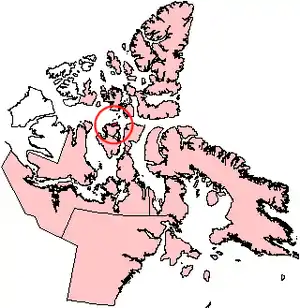
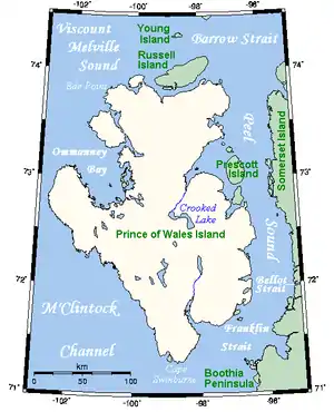 Russell Island nördlich von Prince of Wales Island | ||
Die Insel hat eine Fläche von 940 km².[1] Die höchste Erhebung der Insel erreicht 248 m.[2] Das westliche Drittel der Insel wird von den restlichen zwei Dritteln durch einen schmalen See und dessen Abfluss getrennt. Am Nordende des Sees befindet sich ein lediglich 1,1 km breiter Isthmus.
William Edward Parry entdeckte die Insel im Jahr 1819.[3]
Einzelnachweise
- The Atlas of Canada – Sea Islands (Memento vom 22. Januar 2013 im Internet Archive) (englisch)
- UN SYSTEM-WIDE EARTHWATCH Web Site - Russell
- William Edward Parry: Journal of a voyage for the discovery of a North-West passage from the Atlantic to the Pacific; performed in the years 1819-20, John Murray, 1821, London
Literatur
- Green, David E. C. The Late Quaternary History of Russell Island, N.W.T. Ottawa: National Library of Canada, 1988. ISBN 031532564X
This article is issued from Wikipedia. The text is licensed under Creative Commons - Attribution - Sharealike. The authors of the article are listed here. Additional terms may apply for the media files, click on images to show image meta data.