Kane Basin
Das Kane Basin (grönländisch Ikersuaq) ist der breiteste Teil der Nares-Straße, einer Meerenge, die die Baffin Bay im Süden mit der Lincolnsee, einem Nebenmeer des Arktischen Ozeans, im Norden verbindet. Es ist etwa 180 km lang und bis zu 130 km breit. Begrenzt wird es im Westen von der Ellesmere-Insel im kanadischen Territorium Nunavut und im Osten von Grönland. Im Süden geht das Kane Basin in den Smithsund über, im Norden in den Kennedy-Kanal. Es ist benannt nach dem US-amerikanischen Polarforscher Elisha Kane, der 1853 als erster westlicher Forscher das Gewässer erreichte.
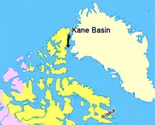
Lage des Kane Basins
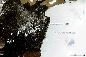
Satellitenbild des Kane Basins, rechts der Humboldt-Gletscher Grönlands
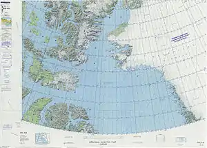
Kane Basin auf dem US-Kartenblatt von 1976
Literatur
- Cold Regions Research and Engineering Laboratory (U.S.). Radar Imagery of Arctic Pack Ice Kane Basin to North Pole. Hanover, N.H.: The Division, 1968.
- Hobbs, William Herbert. Discovery and Exploration Within the Area to the West of the Kane Basin. 1939.
- Kravitz, Joseph. Sediments and Sediment Processes in Kane Basin, a High Arctic Glacial Marine Basin. [Boulder, Colo.?]: University of Colorado, Institute of Arctic and Alpine Research, 1982.
- Marentette, Kris Allen. Late Quaternary Paleoceanography in Kane Basin, Canada and Greenland. Ottawa: National Library of Canada, 1989. ISBN 0-315-43760-X
This article is issued from Wikipedia. The text is licensed under Creative Commons - Attribution - Sharealike. The authors of the article are listed here. Additional terms may apply for the media files, click on images to show image meta data.