Eglinton Island
Eglinton Island ist eine Insel der Königin-Elisabeth-Inseln. Sie liegt in den Nordwest-Territorien Kanadas.
| Eglinton Island | |
|---|---|
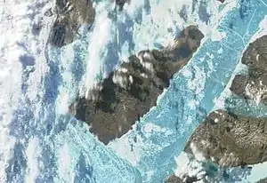 Satellitenbild von Eglinton Island | |
| Gewässer | Arktischer Ozean |
| Inselgruppe | Königin-Elisabeth-Inseln |
| Geographische Lage | 75° 46′ N, 118° 27′ W |
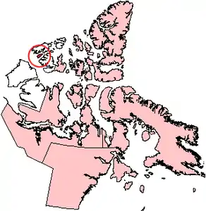 Lage von Eglinton Island | |
| Länge | 73 km |
| Breite | 27 km |
| Fläche | 1 541 km² |
| Höchste Erhebung | 210 m |
| Einwohner | unbewohnt |
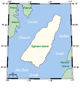 Karte von Eglinton Island | |
Die Insel ist etwa 73 km lang, 9 bis 27 km breit, 1541 km² groß[1] und bis zu 210 m hoch. Eglinton Island ist von der Melville-Insel im Osten durch die Kellett Strait, von der Prinz-Patrick-Insel im Westen durch den Crozier Channel und von der Banksinsel im Süden durch die McClure Strait getrennt.
Die Insel wurde 1853 von George Frederick Mecham (1828–1858) entdeckt, der zur britischen Expedition von Henry Kellett gehörte, die auf der Suche nach dem verschollenen John Franklin war. Im selben Jahr bereiste Francis Leopold McClintock mit dem Hundeschlitten die Westküste der Insel. Sie ist nach Archibald Montgomerie, 13. Earl of Eglinton, (1812–1861) benannt.[2]
Einzelnachweise
- The Atlas of Canada – Sea Islands (Memento vom 22. Januar 2013 im Internet Archive) (englisch)
- William James Mills: Exploring Polar Frontiers. A Historical Encyclopedia. Band 1, ABC-CLIO, Santa Barbara 2003, ISBN 1-57607-422-6, S. 207f.