Prince-of-Wales-Insel (Nunavut)
Die Prince-of-Wales-Insel (oder Fürst-von-Wales-Insel, engl. Prince of Wales Island, Inuktitut Kinngailaq[1]) ist eine Insel im Kanadisch-arktischen Archipel. Verwaltungstechnisch gehört sie zum Territorium Nunavut. Erstmals erkundet wurde sie 1851 von William Kennedy und Joseph-René Bellot bei der Suche nach der verschollenen Arktisexpedition John Franklins. Benannt ist die Insel nach Albert Edward, dem ältesten Sohn von Königin Victoria, dem zehnjährigen Prinzen von Wales. Der spätere König Eduard VII.
| Prince-of-Wales-Insel / Prince of Wales Island / Kinngailaq | |
|---|---|
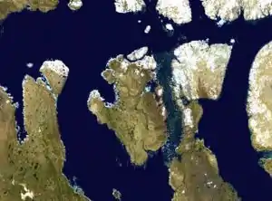 Satelliten-Fotomontage der Prince-of-Wales-Insel | |
| Gewässer | Arktischer Ozean |
| Geographische Lage | 72° 36′ N, 98° 32′ W |
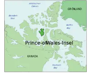 Lage von Prince-of-Wales-Insel / Prince of Wales Island / Kinngailaq | |
| Fläche | 33.339 km² |
| Höchste Erhebung | (unbenannt) 320 m |
| Einwohner | unbewohnt |
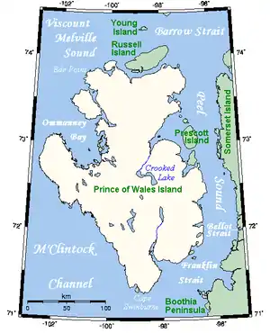 Karte der Insel | |
Geographie
Die südlich der Königin-Elizabeth-Inseln gelegene Insel liegt zwischen der Victoria-Insel im Westen und der Somerset-Insel im Osten. Mit einer Fläche von 33.339 km²[2] belegt sie Platz 10 unter den größten Inseln Kanadas sowie Platz 40 unter den größten Inseln der Erde, weist aber keine permanente Siedlung auf. Ihre Oberfläche ist geprägt von Tundra.
Weblinks
- Prince-of-Wales-Insel (englisch, französisch) In: The Canadian Encyclopedia.
Einzelnachweise
- Darren Keith: Inuit Qaujimaningit Nanurnut Inuit Knowledge of Polar Bears (PDF; 7,0 MB). Gjoa Haven Hunters’ and Trappers’ Organization and CCI Press, 2005, Appendix 5.
- The Atlas of Canada – Sea Islands (Memento vom 6. Oktober 2012 im Internet Archive)