Le Boulay-Morin
| Le Boulay-Morin | ||
|---|---|---|
.svg.png.webp)
|
| |
| Staat | Frankreich | |
| Region | Normandie | |
| Département (Nr.) | Eure (27) | |
| Arrondissement | Évreux | |
| Kanton | Évreux-2 | |
| Gemeindeverband | Évreux Portes de Normandie | |
| Koordinaten | 49° 5′ N, 1° 11′ O | |
| Höhe | 84–147 m | |
| Fläche | 5,53 km² | |
| Einwohner | 798 (1. Januar 2019) | |
| Bevölkerungsdichte | 144 Einw./km² | |
| Postleitzahl | 27930 | |
| INSEE-Code | 27099 | |
| Website | http://www.leboulaymorin.fr | |

Le Boulay-Morin ist eine französische Gemeinde mit 798 Einwohnern (Stand 1. Januar 2019) im Département Eure in der Region Normandie (vor 2016 Haute-Normandie). Sie gehört zum Arrondissement Évreux und zum Kanton Évreux-2 (bis 2015 Évreux-Nord) sowie zum Gemeindeverband Évreux Portes de Normandie. Die Einwohner werden Boulay-Morinois genannt.
Geografie
Le Boulay-Morin liegt etwa sieben Kilometer nordnordöstlich von Évreux. Umgeben wird Le Boulay-Morin von den Nachbargemeinden La Chapelle-du-Bois-des-Faulx und Irreville im Norden, Dardez im Osten und Nordosten, Reuilly im Osten und Südosten, Normanville im Süden und Westen sowie Émalleville im Nordwesten.
Bevölkerungsentwicklung
| Jahr | 1962 | 1968 | 1975 | 1982 | 1990 | 1999 | 2006 | 2013 |
| Einwohner | 188 | 151 | 400 | 457 | 516 | 558 | 641 | 740 |
Sehenswürdigkeiten
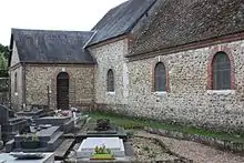
Kirche Saint-André
- Kirche Saint-André aus dem 18. Jahrhundert
- Schloss und Park aus dem 18. Jahrhundert
Weblinks
Commons: Le Boulay-Morin – Sammlung von Bildern, Videos und Audiodateien
Einzelnachweise
This article is issued from Wikipedia. The text is licensed under Creative Commons - Attribution - Sharealike. The authors of the article are listed here. Additional terms may apply for the media files, click on images to show image meta data.